|
search place name
|
||
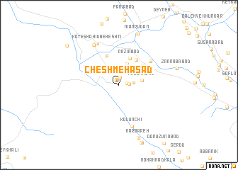
Cheshmeh Asad (Chahār Maḩāll va Bakhtīār, Iran)Cheshmeh Asad is a town in the Chahār Maḩāll va Bakhtīār region of Iran. An overview map of the region around Cheshmeh Asad is displayed below.
regional and 3d topo map of Cheshmeh Asad, Iran ::
Cheshmeh Asad airports ::
The nearest airport is QMJ - Masjed Soleiman Shahid Asyaee, located 95.1 km south west of Cheshmeh Asad.
Other airports nearby include AWZ - Ahwaz (177.7 km south west), MRX - Bandar Mahshahr Mahshahr (226.7 km south west), Nearby towns ::
Cheshmeh Cholak (1.1km north) //
Gel-e Kūshkak (1.2km east) //
Golkūshgak (1.3km east) //
Margh-e Fūlād (1.9km east) //
Naz̧arābād (3.5km north) //
Dehnow-e Soflá (3.5km north east) //
Ma‘şūmābād (3.2km east) //
Raẕīābād (4.5km north) //
Āb Bārīk (4.6km north east) //
Deh Now-ye Pā'īn (4.5km north east) //
Malekābād (5.0km north) //
Deh Now (5.6km north east) //
Kolūnchī (6.7km south) //
Kūy-e Shahīd Beheshtī (7.2km north west) //
Chelgerd (7.2km north west) //
Mīān Rūdān (8.5km north) //
Mārbareh (8.7km south) //
Kār Konān (9.3km north west) //
[all distances 'as the bird flies' and approximate] 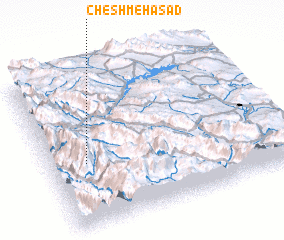 Places with similar names to Cheshmeh Asad, Iran :: Disclaimer :: Information on this page comes without warranty of any kind |
||
|
Where is Cheshmeh Asad? Elevation and coordinates ::
Latitude (lat): 32°24'39"N Longitude (lon): 50°9'25"E
Elevation (approx.): 2491m (map arrows pan, magnifying glasses zoom) |
||
|
Visiting Cheshmeh Asad? Hotel/Accommodation ::
Book a hotel in Cheshmeh Asad Travel Guide ::
Buy a travel guide for Iran rental cars ::
car rental offers GPS waypoint ::
download a GPX waypoint (PoI) of Cheshmeh Asad for your GPS receiver
|
||