|
search place name
|
||
Cheshmeh Īlkhī (Khorāsān, Iran)Cheshmeh Īlkhī is a town in the Khorāsān region of Iran. An overview map of the region around Cheshmeh Īlkhī is displayed below.
regional and 3d topo map of Cheshmeh Īlkhī, Iran ::
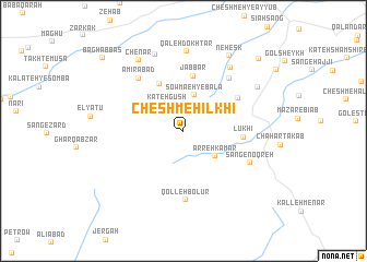
Nearby towns ::
Kateh Gūsh (3.0km north west) //
Şowma‘eh-ye Bālā (3.8km north) //
Arreh Kamar (3.7km south east) //
Şowma‘eh-ye Pā'īn (5.2km north west) //
Jabbār (5.7km north) //
Lūkhī (5.0km east) //
Derakht-e Bīd (5.7km north east) //
Qolleh Bolūr (7.1km south) //
Amīrābād (6.6km north west) //
Kārzār (6.6km north east) //
Sang-e Noqreh (6.5km south east) //
Neyzār (7.6km north east) //
Qal‘eh Dokhtar (8.1km north) //
Kangak (8.1km north) //
Chenār (8.1km north west) //
Kalāteh-ye ‘Abbās (7.6km north east) //
Nehesk (8.6km north east) //
Bar Rūd (9.7km north east) //
Bāgh ‘Abbās (10.0km north west) //
[all distances 'as the bird flies' and approximate] 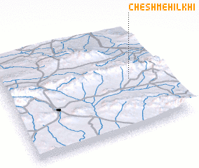 Places with similar names to Cheshmeh Īlkhī, Iran :: Disclaimer :: Information on this page comes without warranty of any kind |
||
|
Where is Cheshmeh Īlkhī? Elevation and coordinates ::
Latitude (lat): 35°30'36"N Longitude (lon): 59°47'54"E
Elevation (approx.): 2107m (map arrows pan, magnifying glasses zoom) |
||
|
Visiting Cheshmeh Īlkhī? Hotel/Accommodation ::
Book a hotel in Cheshmeh Īlkhī Travel Guide ::
Buy a travel guide for Iran rental cars ::
car rental offers GPS waypoint ::
download a GPX waypoint (PoI) of Cheshmeh Īlkhī for your GPS receiver
|
||