|
search place name
|
||
Choqādak (Ostān-e Būshehr, Iran)Choqādak is a town in the Ostān-e Būshehr region of Iran. An overview map of the region around Choqādak is displayed below.
regional and 3d topo map of Choqādak, Iran ::

Choqādak airports ::
The nearest airport is BUZ - Bushehr, located 20.2 km west of Choqādak.
Other airports nearby include SYZ - Shiraz Shahid Dastghaib Intl (163.0 km north east), MRX - Bandar Mahshahr Mahshahr (252.0 km north west), Nearby towns ::
Zā'er Ebrāhīmī (3.9km south east) //
Mīr ‘Abdollāh (4.2km south) //
Seyyed ‘Abdollāh (4.2km south) //
Khowrshīdī (4.2km south) //
‘Ālī Changī (4.3km south east) //
Seyyed 'oseynī (4.9km south) //
Marām'ī (4.9km south) //
Gol Bandī (5.1km south) //
Khvīsh Eshkan (5.8km south) //
Kalebandī (5.8km south) //
Seydā (5.8km south) //
Dezh Gāh (5.8km south) //
Ma‘nā'ī (6.0km south) //
Aḩsham-e Āqā'ī (6.4km south) //
Aḩshām-e Jamāl (6.8km south) //
Mohz̄ ol Ḩoseyn (7.7km south) //
Sartol (8.0km south) //
Pahlavān Koshī-ye Bozorg (8.4km south) //
Boneh Gaz (8.9km south east) //
[all distances 'as the bird flies' and approximate] 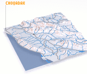 Places with similar names to Choqādak, Iran ::
// Chagoydakh (RU)
// Chekatka (RU)
// Chuckatuck (US)
// Chicticay (EC)
// Sheykh Taqeh (IR)
// Ch'ogaedŏk (KP)
// Shiqidaogou (CN)
// Shakhtayka (RU)
// Siakodougou (CI)
Disclaimer :: Information on this page comes without warranty of any kind |
||
|
Where is Choqādak? Elevation and coordinates ::
Latitude (lat): 28°59'8"N Longitude (lon): 51°2'11"E
Elevation (approx.): 13m (map arrows pan, magnifying glasses zoom) |
||
|
Visiting Choqādak? Hotel/Accommodation ::
Book a hotel in Choqādak Travel Guide ::
Buy a travel guide for Iran rental cars ::
car rental offers GPS waypoint ::
download a GPX waypoint (PoI) of Choqādak for your GPS receiver
|
||