|
search place name
|
||
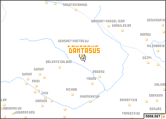
Dam Ţasūs (Ostān-e Kohgīlūyeh va Būyer Aḩmad, Iran)Dam Ţasūs is a town in the Ostān-e Kohgīlūyeh va Būyer Aḩmad region of Iran. An overview map of the region around Dam Ţasūs is displayed below.
regional and 3d topo map of Dam Ţasūs, Iran ::
Dam Ţasūs airports ::
The nearest airport is MRX - Bandar Mahshahr Mahshahr, located 188.6 km west of Dam Ţasūs.
Other airports nearby include SYZ - Shiraz Shahid Dastghaib Intl (189.2 km south east), BUZ - Bushehr (192.7 km south), QMJ - Masjed Soleiman Shahid Asyaee (229.7 km north west), Nearby towns ::
Dam Ţasūs (0.6km south east) //
Ţasūj (2.8km north west) //
Deh Sheykh-e Ţasūj (3.5km north west) //
Pāderū (5.0km south east) //
Qal‘eh-ye Galbūr (4.9km west) //
Yādrū (5.7km south) //
Pīchāb (8.1km south) //
Deh Sheykh-e Delīgān (9.0km north east) //
Barderā (8.5km south west) //
Zīkū (11.4km south west) //
[all distances 'as the bird flies' and approximate] 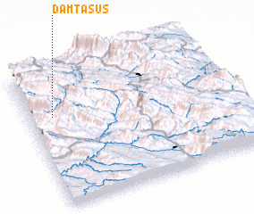 Places with similar names to Dam Ţasūs, Iran ::
// Dam Ţasūs (IR)
Disclaimer :: Information on this page comes without warranty of any kind |
||
|
Where is Dam Ţasūs? Elevation and coordinates ::
Latitude (lat): 30°39'56"N Longitude (lon): 51°6'53"E
Elevation (approx.): 1958m (map arrows pan, magnifying glasses zoom) |
||
|
Visiting Dam Ţasūs? Hotel/Accommodation ::
Book a hotel in Dam Ţasūs Travel Guide ::
Buy a travel guide for Iran rental cars ::
car rental offers GPS waypoint ::
download a GPX waypoint (PoI) of Dam Ţasūs for your GPS receiver
|
||