|
search place name
|
||
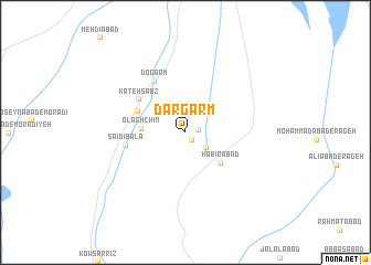
Dar Garm (Kermān, Iran)Dar Garm is a town in the Kermān region of Iran. An overview map of the region around Dar Garm is displayed below.
regional and 3d topo map of Dar Garm, Iran ::
Dar Garm airports ::
The nearest airport is KER - Kerman, located 90.5 km east of Dar Garm.
Other airports nearby include AZD - Yazd Shahid Sadooghi (253.5 km north west), Nearby towns ::
Gūrū Bālā (1.0km south east) //
Gerū'īeh-ye Pā'īn (1.2km east) //
Gerū'īyeh-ye Bālā (2.3km south east) //
Olāghchīn (3.9km west) //
Kabīrābād (4.4km south east) //
Dohū'īyeh (4.7km north west) //
Kateh Sabz (5.3km north west) //
Do Garm (5.8km north west) //
Sa‘īdī Bālā (5.4km west) //
[all distances 'as the bird flies' and approximate]  Places with similar names to Dar Garm, Iran ::
// Treeikrem (NO)
// Darreh Garm (IR)
// Darreh Garm (IR)
// Darreh Garm (IR)
// Darreh Garm (IR)
// Darreh Garmeh (IR)
// Daragrām (BD)
// Dirghagrām (BD)
// Tārgrām (BD)
// Torcoroma (CO)
Disclaimer :: Information on this page comes without warranty of any kind |
||
|
Where is Dar Garm? Elevation and coordinates ::
Latitude (lat): 30°10'41"N Longitude (lon): 56°1'3"E
Elevation (approx.): 2056m (map arrows pan, magnifying glasses zoom) |
||
|
Visiting Dar Garm? Hotel/Accommodation ::
Book a hotel in Dar Garm Travel Guide ::
Buy a travel guide for Iran rental cars ::
car rental offers GPS waypoint ::
download a GPX waypoint (PoI) of Dar Garm for your GPS receiver
|
||