|
search place name
|
||
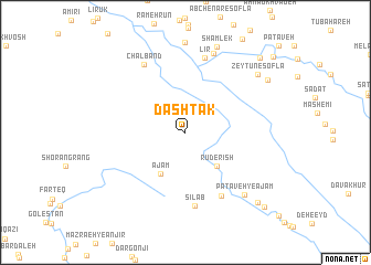
Dashtak (Ostān-e Kohgīlūyeh va Būyer Aḩmad, Iran)Dashtak is a town in the Ostān-e Kohgīlūyeh va Būyer Aḩmad region of Iran. An overview map of the region around Dashtak is displayed below.
regional and 3d topo map of Dashtak, Iran ::
Dashtak airports ::
The nearest airport is QMJ - Masjed Soleiman Shahid Asyaee, located 142.7 km north west of Dashtak.
Other airports nearby include MRX - Bandar Mahshahr Mahshahr (161.2 km south west), AWZ - Ahwaz (171.8 km west), Nearby towns ::
Rūd-e Rīsh (4.3km south east) //
Ājam (4.7km south west) //
Meydān (7.2km south east) //
Sīlāb (7.5km south) //
Līr (7.8km north) //
Chāl Band (7.7km north west) //
Mūr-e Gham (8.3km north) //
Pātāveh-ye Ājam (8.1km south east) //
Shamlek (9.0km north) //
Zeytūn-e Soflá (8.6km north east) //
Kūland (8.8km north east) //
Pātāveh (9.5km south east) //
Mohreh Gham Bālā (9.9km north east) //
Qabā Sūkhteh (10.2km south east) //
La‘l-e Mīneh (10.7km north east) //
[all distances 'as the bird flies' and approximate]  Places with similar names to Dashtak, Iran ::
Disclaimer :: Information on this page comes without warranty of any kind |
||
|
Where is Dashtak? Elevation and coordinates ::
Latitude (lat): 31°20'55"N Longitude (lon): 50°34'1"E
Elevation (approx.): 2465m (map arrows pan, magnifying glasses zoom) |
||
|
Visiting Dashtak? Hotel/Accommodation ::
Book a hotel in Dashtak Travel Guide ::
Buy a travel guide for Iran rental cars ::
car rental offers GPS waypoint ::
download a GPX waypoint (PoI) of Dashtak for your GPS receiver
|
||