|
search place name
|
||
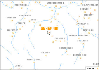
Deh-e Pā'īn (Fārs, Iran)Deh-e Pā'īn is a town in the Fārs region of Iran. An overview map of the region around Deh-e Pā'īn is displayed below.
regional and 3d topo map of Deh-e Pā'īn, Iran ::
Deh-e Pā'īn airports ::
The nearest airport is SYZ - Shiraz Shahid Dastghaib Intl, located 78.1 km south east of Deh-e Pā'īn.
Other airports nearby include BUZ - Bushehr (150.5 km south west), Nearby towns ::
Mashāyekh (1.0km south east) //
Tang-e Sarāb (2.9km south east) //
Gowd Rīzī (3.0km south east) //
Kāydān (3.5km north west) //
Deh Bavā (3.8km north east) //
Cheshmeh Sardū (4.4km north east) //
Gowd Espīd (4.4km south east) //
Deh Now (5.1km north) //
Deh-e Bālā (5.0km north west) //
Kolāh Sīāh (6.0km north) //
Eskandar Beygī (5.4km south east) //
Dam-e Dasht (6.5km north) //
Ḩamzeh Beygī (7.2km north) //
Derk (6.9km north west) //
Gol Zard (8.0km south) //
Darreh Shūr-e Bālā (8.4km north) //
Gardan Kolah (8.2km south east) //
Deh Gerdū (8.5km north west) //
Kolahak (9.7km south east) //
[all distances 'as the bird flies' and approximate] 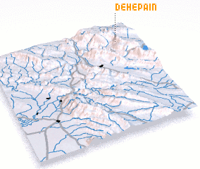 Places with similar names to Deh-e Pā'īn, Iran ::
Disclaimer :: Information on this page comes without warranty of any kind |
||
|
Where is Deh-e Pā'īn? Elevation and coordinates ::
Latitude (lat): 29°55'16"N Longitude (lon): 51°54'43"E
Elevation (approx.): 1837m (map arrows pan, magnifying glasses zoom) |
||
|
Visiting Deh-e Pā'īn? Hotel/Accommodation ::
Book a hotel in Deh-e Pā'īn Travel Guide ::
Buy a travel guide for Iran rental cars ::
car rental offers GPS waypoint ::
download a GPX waypoint (PoI) of Deh-e Pā'īn for your GPS receiver
|
||