|
search place name
|
||
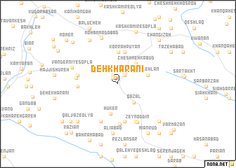
Deh Kharānī (Ostān-e Kermānshāh, Iran)Deh Kharānī is a town in the Ostān-e Kermānshāh region of Iran. An overview map of the region around Deh Kharānī is displayed below.
regional and 3d topo map of Deh Kharānī, Iran ::
Deh Kharānī airports ::
The nearest airport is KSH - Bakhtaran Shahid Ashrafi Esfahani, located 47.7 km south of Deh Kharānī.
Other airports nearby include SDG - Sanandaj (53.1 km north), Nearby towns ::
Vandernī-ye ‘Olyā (1.2km north west) //
Handyāndar (1.6km north west) //
Yazgarān (1.6km north east) //
Dīzgarān (1.8km north east) //
Qazal (3.6km south east) //
Cheshmeh Kabūd (4.0km north east) //
Hūker (4.9km south) //
Qal‘eh Lān (4.1km east) //
Karreh Pūvān (5.1km north) //
Korrahpūyān (5.2km north) //
Tambaleh (6.1km south) //
Hashlī (5.3km west) //
Marzbānī (6.5km south) //
Sākeneh (5.4km west) //
Kahrīz (6.4km south) //
Sūrnī-ye ‘Olyā (6.4km south) //
Kam Shūr (6.4km south) //
Kūlān (6.4km south) //
Dār Tūt (5.5km west) //
Zeyn od Dīn (6.5km south) //
Moḩammadābād (7.6km north) //
Vandernī-ye Soflá (6.5km north west) //
‘Alīābād (7.9km south) //
Garmāb (7.9km north west) //
Qalvaz-e ‘Olyā (8.0km south west) //
Kashkamīr-e Soflá (8.6km north) //
Hartekah (8.1km south east) //
Mīānrūd (8.8km south east) //
Bāqerābād Meyānrūd (8.8km south east) //
[all distances 'as the bird flies' and approximate] 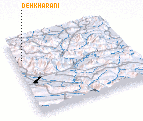
Disclaimer :: Information on this page comes without warranty of any kind |
||
|
Where is Deh Kharānī? Elevation and coordinates ::
Latitude (lat): 34°46'14"N Longitude (lon): 47°4'27"E
Elevation (approx.): 1787m (map arrows pan, magnifying glasses zoom) |
||
|
Visiting Deh Kharānī? Hotel/Accommodation ::
Book a hotel in Deh Kharānī Travel Guide ::
Buy a travel guide for Iran rental cars ::
car rental offers GPS waypoint ::
download a GPX waypoint (PoI) of Deh Kharānī for your GPS receiver
|
||