|
search place name
|
||
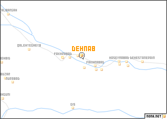
Deh Nāb (Hormozgān, Iran)Deh Nāb is a town in the Hormozgān region of Iran. An overview map of the region around Deh Nāb is displayed below.
regional and 3d topo map of Deh Nāb, Iran ::
Deh Nāb airports ::
The nearest airport is BND - Bandar Abbass Intl, located 164.8 km south east of Deh Nāb.
Other airports nearby include BDH - Bandar Lengeh (225.7 km south), KER - Kerman (244.2 km north east), KIH - Kish Island (263.0 km south west), Nearby towns ::
Khoshnābād (1.3km north west) //
Sarīrān (2.0km south) //
Ḩoseynābād (2.6km west) //
Fakhrābād (2.8km south east) //
Deh-e Nāb (3.5km south east) //
Fakhrābād (4.1km west) //
Deh Now (4.3km south east) //
Estakhr (4.2km west) //
Ḩoseynābād (7.1km east) //
Dashtū (7.2km east) //
[all distances 'as the bird flies' and approximate] 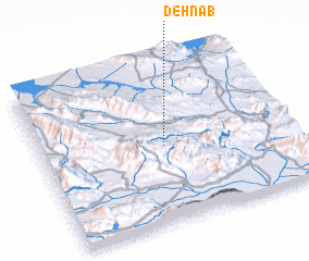 Places with similar names to Deh Nāb, Iran ::
Disclaimer :: Information on this page comes without warranty of any kind |
||
|
Where is Deh Nāb? Elevation and coordinates ::
Latitude (lat): 28°28'47"N Longitude (lon): 55°29'33"E
Elevation (approx.): 1429m (map arrows pan, magnifying glasses zoom) |
||
|
Visiting Deh Nāb? Hotel/Accommodation ::
Book a hotel in Deh Nāb Travel Guide ::
Buy a travel guide for Iran rental cars ::
car rental offers GPS waypoint ::
download a GPX waypoint (PoI) of Deh Nāb for your GPS receiver
|
||