|
search place name
|
||
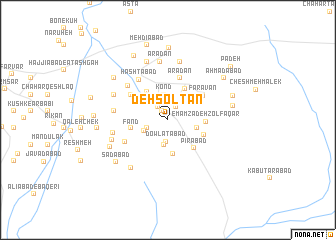
Deh Solţān (Iran)Deh Solţān is a town in Iran. An overview map of the region around Deh Solţān is displayed below.
regional and 3d topo map of Deh Solţān, Iran ::
Deh Solţān airports ::
The nearest airport is THR - Teheran Mehrabad Intl, located 121.4 km north west of Deh Solţān.
Other airports nearby include RZR - Ramsar (251.8 km north west), Nearby towns ::
Ḩoseynābād (1.1km north west) //
Ḩasanābād (1.7km north east) //
Rostamābād (1.7km north west) //
Dowlatābād (2.4km south) //
‘Alīābād-e Bālā (2.1km south west) //
Haft Cheshmeh (2.8km south) //
Kond (2.8km north) //
Kand-e Qolī Khān (2.8km north) //
Yāterī-ye Pā'īn (2.5km south west) //
‘Adlābād (2.8km east) //
Īstgāh-e Yāterī (3.4km north west) //
Shahrak-e Abūz̄ar (3.4km north west) //
Kavīrābād (3.8km south) //
Dāvarābād (3.6km north west) //
Kahnābād (3.8km north east) //
Fand (3.5km west) //
Emāmzādeh Z̄olfaqār (3.5km east) //
Pīrābād (4.0km south east) //
Gadelābād (3.7km south east) //
Faravān (4.2km north east) //
Ārādān (4.8km north) //
Ālū'ak (4.4km north west) //
Amīrābād (4.4km north west) //
Magas Tappeh (4.6km south west) //
Hashtābād (5.2km north west) //
Yāterī-ye Bālā (5.3km north west) //
Qal‘eh-ye Akbarābād (5.0km west) //
Shah Sefīd (5.2km west) //
Ārādān (6.6km north) //
[all distances 'as the bird flies' and approximate] 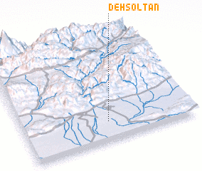 Places with similar names to Deh Solţān, Iran ::
Disclaimer :: Information on this page comes without warranty of any kind |
||
|
Where is Deh Solţān? Elevation and coordinates ::
Latitude (lat): 35°11'29"N Longitude (lon): 52°30'15"E
Elevation (approx.): 836m (map arrows pan, magnifying glasses zoom) |
||
|
Visiting Deh Solţān? Hotel/Accommodation ::
Book a hotel in Deh Solţān Travel Guide ::
Buy a travel guide for Iran rental cars ::
car rental offers GPS waypoint ::
download a GPX waypoint (PoI) of Deh Solţān for your GPS receiver
|
||