|
search place name
|
||
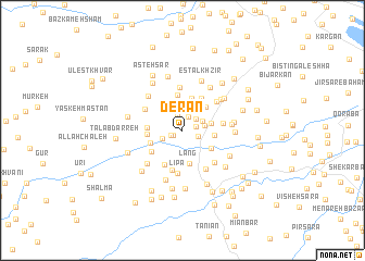
Derān (Gīlān, Iran)Derān is a town in the Gīlān region of Iran. An overview map of the region around Derān is displayed below.
regional and 3d topo map of Derān, Iran ::
Derān airports ::
The nearest airport is RAS - Rasht, located 45.7 km east of Derān.
Other airports nearby include RZR - Ramsar (151.0 km east), Nearby towns ::
Kofūd Mozhdeh (0.9km south west) //
Pashed (1.1km south west) //
Chāleh Sarā (1.2km east) //
Bītam (1.5km north) //
Chapeh Zād (1.6km north) //
Shālekeh (1.4km south east) //
Khalavarjān (1.6km north east) //
Zarrīn Dūl (1.8km south west) //
Pīr Sarā (1.9km north east) //
Kharf Kūreh (1.9km east) //
Pāshkam (2.5km east) //
Shāndarman (3.0km north east) //
Tūseh Sarā (2.7km east) //
Kūrehjān (3.3km north) //
Lang (3.4km south) //
Mīleh Sarā (3.0km south east) //
Borj Rāh (2.9km south west) //
Vezmtar (3.6km north) //
Nīlāsh (2.9km west) //
Rashkūm (2.9km west) //
Mīr Maḩalleh (3.6km north east) //
Sīāh Mard (3.3km south west) //
Markīyeh (3.8km south west) //
Bāzār Jom‘eh (3.4km east) //
Razīn Dūl (4.2km south) //
Līpā (4.4km south) //
Chat Bon (3.7km north west) //
Ūlom (4.5km north) //
Chamūsh Dūzān (4.1km north east) //
[all distances 'as the bird flies' and approximate]  Places with similar names to Derān, Iran ::
Disclaimer :: Information on this page comes without warranty of any kind |
||
|
Where is Derān? Elevation and coordinates ::
Latitude (lat): 37°25'15"N Longitude (lon): 49°6'14"E
Elevation (approx.): 75m (map arrows pan, magnifying glasses zoom) |
||
|
Visiting Derān? Hotel/Accommodation ::
Book a hotel in Derān Travel Guide ::
Buy a travel guide for Iran rental cars ::
car rental offers GPS waypoint ::
download a GPX waypoint (PoI) of Derān for your GPS receiver
|
||