|
search place name
|
||
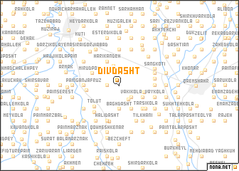
Dīv Dasht (Iran)Dīv Dasht is a town in Iran. An overview map of the region around Dīv Dasht is displayed below.
regional and 3d topo map of Dīv Dasht, Iran ::
Dīv Dasht airports ::
The nearest airport is THR - Teheran Mehrabad Intl, located 155.5 km south west of Dīv Dasht.
Nearby towns ::
Tarājī Kolā (1.5km west) //
Vākī Kolā (2.4km south east) //
Khaţīr Kolā (2.5km south east) //
Hatkeh Posht (3.1km north) //
Gāvān Āhangar (3.7km south) //
Bāgh Dasht (3.7km south) //
Qarā Kheyl (3.3km east) //
Qandarī (3.5km south east) //
Bargaman Kheyl (3.5km south east) //
Shāmī Kolā (3.5km south east) //
Fenderī-ye Nām Āvar (3.5km south east) //
Bī Kolā (3.5km south east) //
Harī Kandeh (4.0km north) //
Meydān Sar (4.0km south) //
Mīrūd Posht (3.9km north west) //
Tolūt (4.6km south west) //
Rowshanābād (4.2km west) //
Shūmī Kolā (4.8km south east) //
Ţarsī Kolā (4.9km south east) //
Pā'īn Ganj Afrūz (4.5km west) //
Khormā Kolā (4.5km east) //
Lākīl (4.5km east) //
Deh Mīān (4.5km west) //
Janīd (4.5km east) //
Darī Kandeh (5.6km north) //
Chamāz Kolā (5.6km north) //
Naqīb Kolā-ye S̄alās (4.6km east) //
Chārī (5.3km south west) //
Afrā Kotī (4.8km north east) //
[all distances 'as the bird flies' and approximate]  Places with similar names to Dīv Dasht, Iran ::
Disclaimer :: Information on this page comes without warranty of any kind |
||
|
Where is Dīv Dasht? Elevation and coordinates ::
Latitude (lat): 36°28'0"N Longitude (lon): 52°45'0"E
Elevation (approx.): 25m (map arrows pan, magnifying glasses zoom) |
||
|
Visiting Dīv Dasht? Hotel/Accommodation ::
Book a hotel in Dīv Dasht Travel Guide ::
Buy a travel guide for Iran rental cars ::
car rental offers GPS waypoint ::
download a GPX waypoint (PoI) of Dīv Dasht for your GPS receiver
|
||