|
search place name
|
||
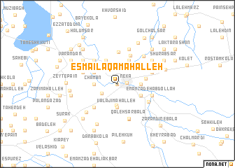
Esmā‘īl Āqā Maḩalleh (Iran)Esmā‘īl Āqā Maḩalleh is a town in Iran. An overview map of the region around Esmā‘īl Āqā Maḩalleh is displayed below.
regional and 3d topo map of Esmā‘īl Āqā Maḩalleh, Iran ::
Esmā‘īl Āqā Maḩalleh airports ::
The nearest airport is THR - Teheran Mehrabad Intl, located 206.8 km south west of Esmā‘īl Āqā Maḩalleh.
Nearby towns ::
Dowqānlū (0.0km north) //
Nekā (1.2km east) //
Now Dehak (2.6km south west) //
Ālūkandeh (2.8km north west) //
Sīāvash Kolā (3.1km north) //
Owmāl (3.4km south) //
Berījān (3.7km south) //
Valajī Maḩalleh (3.7km south) //
Chamān (3.0km west) //
Ābelū (3.0km east) //
Tāzehābād-e Bostān Kheyl (4.0km north) //
Nīm Chāh (4.0km north) //
Ḩājjī Maḩalleh (3.5km north west) //
Gol Bestān (3.5km south east) //
Kalestān (3.5km south east) //
Chāleh Pol (3.7km east) //
Valāshed-e Bālā (4.8km north) //
Ţūs Kolā (5.0km north) //
Şafarābād (4.8km south west) //
Gīlābād (4.8km north west) //
Bezamīnābād (4.8km north west) //
Zarandīn-e Pā'īn (4.9km south east) //
Mīān Goleh (4.9km north east) //
Qal‘eh Sar-e Pā'īn (5.8km south) //
Chenār Bon (4.8km north east) //
Emāmzādeh ‘Abdollāh (4.8km south east) //
Valāshed-e Pā'īn (5.8km north) //
Tappeh (5.8km north) //
Shahāb ed Dīn (5.8km north) //
[all distances 'as the bird flies' and approximate]  Places with similar names to Esmā‘īl Āqā Maḩalleh, Iran :: Disclaimer :: Information on this page comes without warranty of any kind |
||
|
Where is Esmā‘īl Āqā Maḩalleh? Elevation and coordinates ::
Latitude (lat): 36°39'0"N Longitude (lon): 53°17'0"E
Elevation (approx.): 35m (map arrows pan, magnifying glasses zoom) |
||
|
Visiting Esmā‘īl Āqā Maḩalleh? Hotel/Accommodation ::
Book a hotel in Esmā‘īl Āqā Maḩalleh Travel Guide ::
Buy a travel guide for Iran rental cars ::
car rental offers GPS waypoint ::
download a GPX waypoint (PoI) of Esmā‘īl Āqā Maḩalleh for your GPS receiver
|
||