|
search place name
|
||
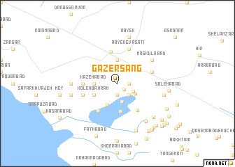
Gāzer Sang (Iran)Gāzer Sang is a town in Iran. An overview map of the region around Gāzer Sang is displayed below.
regional and 3d topo map of Gāzer Sang, Iran ::
Gāzer Sang airports ::
The nearest airport is THR - Teheran Mehrabad Intl, located 78.5 km south east of Gāzer Sang.
Other airports nearby include RZR - Ramsar (101.8 km north), RAS - Rasht (168.8 km north west), Nearby towns ::
Ozbakī (1.3km south east) //
Meskīnābād (1.5km east) //
Moşaddeq (1.9km south) //
Jalīlābād (2.4km south east) //
Maghrūrābād (2.5km south east) //
Ḩasanābād (3.0km south) //
Khvājeh Jamāl od Dīn (2.8km south east) //
Kāz̧emābād (3.0km west) //
Ābyek-e Soflā (3.7km north) //
Naz̧arābād-e Kūchek (3.7km south) //
Koleh Bahrām (3.5km south west) //
Kāshānī (3.5km south west) //
Reẕāābād (4.5km south) //
Ābyek (5.1km north) //
Moḩammadābād-e Naz̧arābād (5.0km south east) //
Bāqerābād-e Fāẕel (5.1km south west) //
Ḩoseynābād-e Kord (4.5km west) //
Ābyek-e Vasaţī (5.8km north) //
Bāgh Angūr-e Hīv (4.9km east) //
Eslāmābād (4.9km west) //
Ḩasan Bakūl (4.9km west) //
Maskūlābād (5.8km north east) //
Āḩmadābād-e Kāshānī (6.0km west) //
Qūch Ḩeşār (7.1km south east) //
Qal‘eh-ye Sheykh (6.3km west) //
Ābyek (7.6km north) //
Ābyek-e ‘Olyā (7.6km north) //
Mehdīābād (6.3km east) //
Shahrak-e Fakhr-e Īrān (7.1km south east) //
[all distances 'as the bird flies' and approximate] 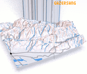 Places with similar names to Gāzer Sang, Iran ::
// Kościerzynek (PL)
Disclaimer :: Information on this page comes without warranty of any kind |
||
|
Where is Gāzer Sang? Elevation and coordinates ::
Latitude (lat): 36°0'0"N Longitude (lon): 50°32'0"E
Elevation (approx.): 1186m (map arrows pan, magnifying glasses zoom) |
||
|
Visiting Gāzer Sang? Hotel/Accommodation ::
Book a hotel in Gāzer Sang Travel Guide ::
Buy a travel guide for Iran rental cars ::
car rental offers GPS waypoint ::
download a GPX waypoint (PoI) of Gāzer Sang for your GPS receiver
|
||