|
search place name
|
||
Geleh Anjīreh (Eşfahān, Iran)Geleh Anjīreh is a town in the Eşfahān region of Iran. An overview map of the region around Geleh Anjīreh is displayed below.
regional and 3d topo map of Geleh Anjīreh, Iran ::
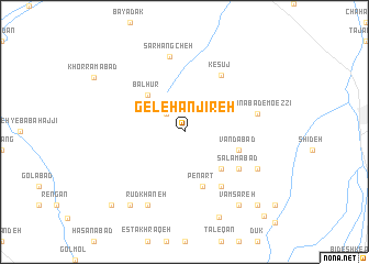
Nearby towns ::
Sar Jahan (2.4km north west) //
Balhūr (4.8km north west) //
Haramābād (4.8km south east) //
Vandābād (5.0km east) //
Penārt (5.8km south) //
Lākūh (6.4km south east) //
Salāmābād (5.9km south east) //
Kesūj (6.5km north east) //
Ḩasanābād-e Mo‘ezzī (6.5km east) //
Sarhangcheh (7.8km north) //
Rūdkhāneh (8.0km south west) //
Deh Gerdīān (7.2km south east) //
Shīrāzān (8.7km south east) //
Vām Sāreh (8.7km south east) //
Līch (8.7km south west) //
Kachū Sang (9.1km south) //
Seynā (9.7km south east) //
Cheshmeh Sorkheh (9.7km south west) //
Hombar (10.9km south east) //
[all distances 'as the bird flies' and approximate] 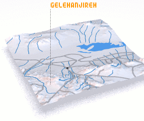 Places with similar names to Geleh Anjīreh, Iran :: Disclaimer :: Information on this page comes without warranty of any kind |
||
|
Where is Geleh Anjīreh? Elevation and coordinates ::
Latitude (lat): 33°22'0"N Longitude (lon): 52°12'0"E
Elevation (approx.): 1494m (map arrows pan, magnifying glasses zoom) |
||
|
Visiting Geleh Anjīreh? Hotel/Accommodation ::
Book a hotel in Geleh Anjīreh Travel Guide ::
Buy a travel guide for Iran rental cars ::
car rental offers GPS waypoint ::
download a GPX waypoint (PoI) of Geleh Anjīreh for your GPS receiver
|
||