|
search place name
|
||
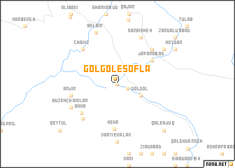
Golgol-e Soflá (Īlām, Iran)Golgol-e Soflá is a town in the Īlām region of Iran. An overview map of the region around Golgol-e Soflá is displayed below.
regional and 3d topo map of Golgol-e Soflá, Iran ::
Golgol-e Soflá airports ::
The nearest airport is KSH - Bakhtaran Shahid Ashrafi Esfahani, located 115.8 km north east of Golgol-e Soflá.
Other airports nearby include SDG - Sanandaj (203.2 km north), Nearby towns ::
Sarjū'ī (0.0km north) //
Golgol-e ‘Olyā (1.5km south east) //
Gol Gol (3.6km south east) //
Ja‘farābād (5.9km north east) //
Mehr (7.2km south) //
Ammā (6.7km south west) //
Anjīr (6.5km west) //
Anjīr (7.2km south west) //
Chāvīz (7.2km north west) //
Kolah Kabūd (7.2km north east) //
Būzeh Chamīlān (7.2km south west) //
Sar Bīsheh (8.0km north east) //
Belbīn (8.7km north) //
Maḩmūdābād (8.3km north east) //
Qal‘eh Jūq (9.7km south east) //
[all distances 'as the bird flies' and approximate] 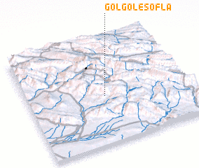 Places with similar names to Golgol-e Soflá, Iran ::
// Gol Gol-e Soflá (IR)
// Gol Gol-e Soflá (IR)
Disclaimer :: Information on this page comes without warranty of any kind |
||
|
Where is Golgol-e Soflá? Elevation and coordinates ::
Latitude (lat): 33°28'0"N Longitude (lon): 46°29'0"E
Elevation (approx.): 1089m (map arrows pan, magnifying glasses zoom) |
||
|
Visiting Golgol-e Soflá? Hotel/Accommodation ::
Book a hotel in Golgol-e Soflá Travel Guide ::
Buy a travel guide for Iran rental cars ::
car rental offers GPS waypoint ::
download a GPX waypoint (PoI) of Golgol-e Soflá for your GPS receiver
|
||