|
search place name
|
||
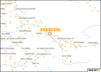
Ḩabībvand (Lorestān, Iran)Ḩabībvand is a town in the Lorestān region of Iran. An overview map of the region around Ḩabībvand is displayed below.
regional and 3d topo map of Ḩabībvand, Iran ::
Ḩabībvand airports ::
The nearest airport is KSH - Bakhtaran Shahid Ashrafi Esfahani, located 93.6 km west of Ḩabībvand.
Other airports nearby include SDG - Sanandaj (165.6 km north west), Nearby towns ::
Sorkhānjūb-e ‘Olyā (0.0km north) //
Sorkhānjūb (0.0km north) //
Gandom Bān (0.9km south east) //
Yūsefī (1.3km west) //
Īrānshāh (1.5km south east) //
Moḩammad Mīrzā'ī (1.5km east) //
‘Abd ol Ḩoseyn (1.5km east) //
Sorkhānjūb-e Vosţá (1.5km west) //
‘Alīmīrzā'ī-ye ‘Olyā (2.0km south) //
Sorkhānjūb-e Soflá (2.0km north west) //
Z̄olīvār (2.2km north west) //
‘Alī Mīrzā'ī-ye Soflá (2.4km south east) //
‘Alīmīrzā'ī-ye Vosţá (2.4km south east) //
Āqā Abūl (2.4km south east) //
Qūrn‘alī (2.4km north west) //
Sorkhān Jūb (2.4km north west) //
Deh Farrokh (3.6km south east) //
Bagverdī-ye Soflá (3.6km south east) //
Raḩīmābād (3.6km south east) //
Shahnābād (4.0km north) //
Zamāneh (3.6km north west) //
Yūrqolī (3.6km north west) //
Kaleh Jūb (3.6km north west) //
Sharīf (3.5km west) //
Moḩammadjān-e Falak od Dīn (3.9km south east) //
Karamelāhī (4.0km north west) //
Sālīāneh (3.9km north west) //
Kan Sorkheh (4.5km south east) //
Cherāgh (4.8km south east) //
[all distances 'as the bird flies' and approximate]  Places with similar names to Ḩabībvand, Iran :: Disclaimer :: Information on this page comes without warranty of any kind |
||
|
Where is Ḩabībvand? Elevation and coordinates ::
Latitude (lat): 34°4'0"N Longitude (lon): 48°7'0"E
Elevation (approx.): 1844m (map arrows pan, magnifying glasses zoom) |
||
|
Visiting Ḩabībvand? Hotel/Accommodation ::
Book a hotel in Ḩabībvand Travel Guide ::
Buy a travel guide for Iran rental cars ::
car rental offers GPS waypoint ::
download a GPX waypoint (PoI) of Ḩabībvand for your GPS receiver
|
||