|
search place name
|
||
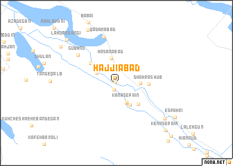
Ḩājjīābād (Iran)Ḩājjīābād is a town in Iran. An overview map of the region around Ḩājjīābād is displayed below.
regional and 3d topo map of Ḩājjīābād, Iran ::
Ḩājjīābād airports ::
The nearest airport is SYZ - Shiraz Shahid Dastghaib Intl, located 108.8 km south of Ḩājjīābād.
Other airports nearby include AZD - Yazd Shahid Sadooghi (230.0 km north east), BUZ - Bushehr (236.2 km south west), Nearby towns ::
Lah Shotor Khānī (0.2km north west) //
Angakbān (1.1km south) //
Lah Sangī (2.6km north) //
Allāhābād (2.9km north east) //
Ardeh ‘Alī (3.2km north west) //
Kanās-e Pā'īn (3.4km south east) //
Ja‘farābād (3.2km north west) //
Kanās-e Bālā (3.6km south) //
Rāsteh (3.4km east) //
Ḩasanābād (4.1km north) //
Jadval-e Now (4.0km south east) //
Jadval-e Now (4.0km south east) //
Eshkaft Khān (4.6km south east) //
Eshkaft Khān (4.6km south east) //
Shahr Āshūb (4.5km east) //
Deh Kheyr (4.9km north west) //
Gūbānd (7.0km north west) //
Qadamābād (7.7km north) //
Shahr-e Bālā (8.8km south east) //
Bīsheh-ye Bābā'ī (9.4km north west) //
Lah Darsangī (9.8km north west) //
Kenās-e Pā'īn (10.2km south east) //
Kenās-e Pā'īn (10.2km south east) //
Vaḩān (11.4km south east) //
[all distances 'as the bird flies' and approximate] 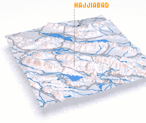 Places with similar names to Ḩājjīābād, Iran ::
Disclaimer :: Information on this page comes without warranty of any kind |
||
|
Where is Ḩājjīābād? Elevation and coordinates ::
Latitude (lat): 30°31'0"N Longitude (lon): 52°29'0"E
Elevation (approx.): 2137m (map arrows pan, magnifying glasses zoom) |
||
|
Visiting Ḩājjīābād? Hotel/Accommodation ::
Book a hotel in Ḩājjīābād Travel Guide ::
Buy a travel guide for Iran rental cars ::
car rental offers GPS waypoint ::
download a GPX waypoint (PoI) of Ḩājjīābād for your GPS receiver
|
||