|
search place name
|
||
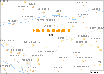
Ḩasanābād-e Ābdar (Hamadān, Iran)Ḩasanābād-e Ābdar is a town in the Hamadān region of Iran. An overview map of the region around Ḩasanābād-e Ābdar is displayed below.
regional and 3d topo map of Ḩasanābād-e Ābdar, Iran ::
Ḩasanābād-e Ābdar airports ::
The nearest airport is KSH - Bakhtaran Shahid Ashrafi Esfahani, located 118.7 km west of Ḩasanābād-e Ābdar.
Other airports nearby include SDG - Sanandaj (169.9 km north west), Nearby towns ::
Tagargī (2.3km north east) //
Dehlaq (3.0km north west) //
Ābdar (3.3km south east) //
Bānesareh (4.0km south) //
Lūlūhar (4.4km north) //
Darreh-ye Omīd ‘Alī (5.3km north) //
Dūrījān (5.1km north east) //
Mūdārān (6.7km north) //
Qal‘eh-ye Bārūdāb (6.7km south) //
Āvarzamān (6.1km east) //
Qeshlāq-e Deh Fūl (6.4km south west) //
Do Cheshmeh (6.6km south west) //
Mūzelān (7.5km north east) //
Jarīā (8.6km north) //
Kheyr Qolī (9.0km south west) //
‘Oshvand (9.2km south) //
Shahbāzābād (9.5km south west) //
Shahvarābād (9.7km south west) //
Belartū (9.3km north east) //
Deh Sorkheh (9.6km north west) //
Anjīreh (10.0km south east) //
[all distances 'as the bird flies' and approximate] 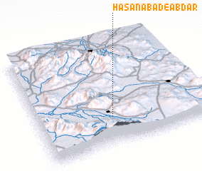 Places with similar names to Ḩasanābād-e Ābdar, Iran :: Disclaimer :: Information on this page comes without warranty of any kind |
||
|
Where is Ḩasanābād-e Ābdar? Elevation and coordinates ::
Latitude (lat): 34°16'35"N Longitude (lon): 48°26'43"E
Elevation (approx.): 1796m (map arrows pan, magnifying glasses zoom) |
||
|
Visiting Ḩasanābād-e Ābdar? Hotel/Accommodation ::
Book a hotel in Ḩasanābād-e Ābdar Travel Guide ::
Buy a travel guide for Iran rental cars ::
car rental offers GPS waypoint ::
download a GPX waypoint (PoI) of Ḩasanābād-e Ābdar for your GPS receiver
|
||