|
search place name
|
||
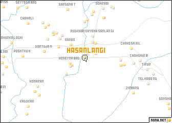
Ḩasan Langī (Hormozgān, Iran)Ḩasan Langī is a town in the Hormozgān region of Iran. An overview map of the region around Ḩasan Langī is displayed below.
regional and 3d topo map of Ḩasan Langī, Iran ::
Ḩasan Langī airports ::
The nearest airport is BND - Bandar Abbass Intl, located 48.8 km west of Ḩasan Langī.
Other airports nearby include KHS - Khasab (144.1 km south west), RKT - Ras Al Khaimah Intl (212.8 km south west), Nearby towns ::
Sardangān (1.7km north) //
Gazakī (2.4km north east) //
Membar (2.5km north east) //
Gāv Mordeh (2.9km west) //
Ḩoseynābād (3.1km west) //
Mehraqān (3.2km west) //
Gū Gāvī (4.4km north) //
Bīst Manī (4.3km north east) //
Narān (4.7km north west) //
Konārān (4.7km south west) //
Rūdkhāneh-ye Ḩasan Langī (5.7km north) //
Kūlaqān-e Dartūjān (6.2km north west) //
Bāqerābād (7.0km north west) //
Chāh Semāl (6.7km east) //
Shāhbāzān (7.2km north west) //
Kharbandavān (6.8km east) //
Khar Bandān (7.4km east) //
Kormūn (8.7km north) //
Kanīz Qanbarī (8.4km north west) //
Balūchakī (8.6km north west) //
Kal Z̄orrat (9.1km north west) //
Pā Qalātān (8.9km north west) //
Kashkū'īyeh (10.8km north west) //
Chāh Pas (10.8km north west) //
[all distances 'as the bird flies' and approximate] 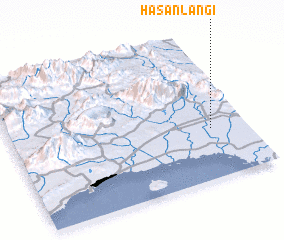 Places with similar names to Ḩasan Langī, Iran :: Disclaimer :: Information on this page comes without warranty of any kind |
||
|
Where is Ḩasan Langī? Elevation and coordinates ::
Latitude (lat): 27°21'5"N Longitude (lon): 56°50'52"E
Elevation (approx.): 24m (map arrows pan, magnifying glasses zoom) |
||
|
Visiting Ḩasan Langī? Hotel/Accommodation ::
Book a hotel in Ḩasan Langī Travel Guide ::
Buy a travel guide for Iran rental cars ::
car rental offers GPS waypoint ::
download a GPX waypoint (PoI) of Ḩasan Langī for your GPS receiver
|
||