|
search place name
|
||
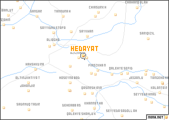
Hedāyat (Ostān-e Kermānshāh, Iran)Hedāyat is a town in the Ostān-e Kermānshāh region of Iran. An overview map of the region around Hedāyat is displayed below.
regional and 3d topo map of Hedāyat, Iran ::
Hedāyat airports ::
The nearest airport is KSH - Bakhtaran Shahid Ashrafi Esfahani, located 148.9 km east of Hedāyat.
Other airports nearby include SDG - Sanandaj (151.6 km north east), Nearby towns ::
Majīd Sālār (0.7km north east) //
‘Azīz Khān (1.2km north west) //
Ţayrūq (3.1km south east) //
Gomrok Kohneh (2.9km south west) //
Fīrōz Khān (3.3km south east) //
Aḩmadābād (3.8km south east) //
Saykwan (5.3km north) //
Ḩoseynābād (5.7km south west) //
Nīārūq (6.0km south east) //
Kānī Shīrīn (6.8km north) //
Deh-e Salīm (7.5km south) //
‘Alī Āghā (6.5km north west) //
Karīmābād (7.3km south) //
Āqdāgh (7.4km south) //
Qaşr-e Shīrīn (7.6km south) //
Qora To (7.1km north west) //
Qal‘eh-ye Sefīd (7.4km south east) //
Sayyid Muşţafá (8.3km north west) //
[all distances 'as the bird flies' and approximate] 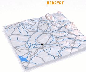
Disclaimer :: Information on this page comes without warranty of any kind |
||
|
Where is Hedāyat? Elevation and coordinates ::
Latitude (lat): 34°34'44"N Longitude (lon): 45°33'42"E
Elevation (approx.): 312m (map arrows pan, magnifying glasses zoom) |
||
|
Visiting Hedāyat? Hotel/Accommodation ::
Book a hotel in Hedāyat Travel Guide ::
Buy a travel guide for Iran rental cars ::
car rental offers GPS waypoint ::
download a GPX waypoint (PoI) of Hedāyat for your GPS receiver
|
||