|
search place name
|
||
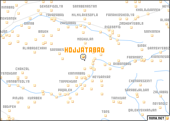
Ḩojjatābād (Lorestān, Iran)Ḩojjatābād is a town in the Lorestān region of Iran. An overview map of the region around Ḩojjatābād is displayed below.
regional and 3d topo map of Ḩojjatābād, Iran ::
Ḩojjatābād airports ::
The nearest airport is KSH - Bakhtaran Shahid Ashrafi Esfahani, located 168.6 km north west of Ḩojjatābād.
Other airports nearby include QMJ - Masjed Soleiman Shahid Asyaee (169.0 km south), SDG - Sanandaj (250.2 km north west), Nearby towns ::
Ḩasanābād (1.5km east) //
Sangābād (1.9km south) //
Kadkhodā Malūs (1.6km south east) //
‘Alīābād (1.9km south east) //
Aḩmadābād (1.8km east) //
Zarīlān-e Mamīl (2.4km north east) //
Darvīshābād (2.4km south east) //
Reẕāābād (2.6km south east) //
Vazleh (3.0km north) //
Īmānābād (3.5km south) //
Sardārābād (3.7km south) //
Kasehābād (3.2km north east) //
Moghūlān (3.9km north) //
Seyfābād (3.9km south) //
Jahāngīrābād (4.0km south) //
Karīmābād (4.0km south west) //
Ja‘farābād (3.8km east) //
‘Alīābād (4.7km south) //
Gandāveh (4.1km west) //
Gīlāvand (5.3km south) //
Qal‘eh-ye Sheykh (4.6km east) //
Ḩasanābād-e Gīlāvand (5.6km south) //
Sarāb-e Sūrī (4.9km west) //
Ḩeydar Kar (5.5km south east) //
Deh-e Now (5.0km east) //
Abolābād-e Gīlāvand (5.8km south) //
Bādeh (6.2km north) //
Jahānābād (6.3km south) //
Gandābeh (6.4km south) //
[all distances 'as the bird flies' and approximate]  Places with similar names to Ḩojjatābād, Iran ::
// Ḩojjatābād (IR)
// Ḩojjatābād (IR)
// Ḩojjatābād (IR)
// Ḩojjatābād (IR)
// Ḩojjatābād (IR)
// Ḩojjatābād (IR)
// Ḩojjatābād (IR)
// Ḩojjatābād (IR)
// Ḩojjatābād (IR)
// Ḩojjatābād (IR)
Disclaimer :: Information on this page comes without warranty of any kind |
||
|
Where is Ḩojjatābād? Elevation and coordinates ::
Latitude (lat): 33°25'0"N Longitude (lon): 48°36'0"E
Elevation (approx.): 1689m (map arrows pan, magnifying glasses zoom) |
||
|
Visiting Ḩojjatābād? Hotel/Accommodation ::
Book a hotel in Ḩojjatābād Travel Guide ::
Buy a travel guide for Iran rental cars ::
car rental offers GPS waypoint ::
download a GPX waypoint (PoI) of Ḩojjatābād for your GPS receiver
|
||