|
search place name
|
||
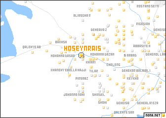
Ḩoseyn Ra'īs (Sīstān va Balūchestān, Iran)Ḩoseyn Ra'īs is a town in the Sīstān va Balūchestān region of Iran. An overview map of the region around Ḩoseyn Ra'īs is displayed below.
regional and 3d topo map of Ḩoseyn Ra'īs, Iran ::
Ḩoseyn Ra'īs airports ::
The nearest airport is ZAH - Zahedan Intl, located 165.0 km south of Ḩoseyn Ra'īs.
Nearby towns ::
Jahān Bakhsh (0.0km north) //
Deh-e Loţfollāh (0.5km north) //
Ḩoseynā (1.4km east) //
Deh-e Gholām Mālek (1.9km north) //
Deh-e Akbar Ja‘farī (1.9km north) //
‘Alī Reẕā (1.6km west) //
Deh-e Ās (1.9km north) //
Eslāmābād (2.0km east) //
Deh-e Esmā‘īl (2.4km north west) //
‘Alī Ḩoseyn (2.4km north west) //
Deh-e ‘Abbās Khān (2.4km north west) //
Khīārī (2.4km south east) //
Jamālābād (2.5km east) //
Ḩoseyn Mashhadī (2.9km north east) //
Deh-e Maḩmūd (3.0km north east) //
Moḩammad Şafar (3.0km south west) //
Dādallāh (3.3km north east) //
Deh-e Kadkhodā Golzār (3.3km north west) //
Deh-e Şāḩebkhān (3.7km north) //
Deh Now (4.0km north west) //
Ḩasanābād (4.1km south east) //
Ḩasan ‘Abdollāh (3.8km north east) //
Ja‘far Shahbāz (3.8km north west) //
Moḩammad Āsār (3.8km west) //
Pūdīneh (4.5km north) //
Moḩammad A‘z̧am (3.9km east) //
Gorg (4.4km south east) //
Tīlar (4.5km south east) //
Khāneh-ye Mollā Ḩājjī (4.4km south west) //
[all distances 'as the bird flies' and approximate]  Places with similar names to Ḩoseyn Ra'īs, Iran ::
// Hǝsǝnriz (AZ)
// Ḩişn ar Raʼş (YE)
Disclaimer :: Information on this page comes without warranty of any kind |
||
|
Where is Ḩoseyn Ra'īs? Elevation and coordinates ::
Latitude (lat): 30°55'0"N Longitude (lon): 61°20'0"E
Elevation (approx.): 480m (map arrows pan, magnifying glasses zoom) |
||
|
Visiting Ḩoseyn Ra'īs? Hotel/Accommodation ::
Book a hotel in Ḩoseyn Ra'īs Travel Guide ::
Buy a travel guide for Iran rental cars ::
car rental offers GPS waypoint ::
download a GPX waypoint (PoI) of Ḩoseyn Ra'īs for your GPS receiver
|
||