|
search place name
|
||
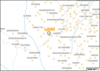
Ījdān (Tehrān, Iran)Ījdān is a town in the Tehrān region of Iran. An overview map of the region around Ījdān is displayed below.
regional and 3d topo map of Ījdān, Iran ::
Ījdān airports ::
The nearest airport is THR - Teheran Mehrabad Intl, located 50.9 km north west of Ījdān.
Other airports nearby include RZR - Ramsar (197.6 km north west), Nearby towns ::
Shamsābād (0.5km east) //
Karīmābād (2.0km north west) //
Qeshlāq-e Shamsābād (2.1km south) //
Moḩammadīyeh (2.1km west) //
Ḩoseynābād-e Javāherī (2.6km north) //
Ījdānak (2.1km east) //
‘Alīābād (3.0km south west) //
Yūsefābād-e Khāleşeh (3.0km north) //
Neshāţīyeh (2.8km west) //
Khāledābād (3.3km south east) //
Qāsemābād (3.8km south west) //
Kavīrābād (4.2km south) //
Āb Bārīk (4.0km south east) //
Vīlīkeh (3.9km east) //
Chāleh Ghāzān (4.7km south) //
Eqbālīyeh (4.2km north west) //
Aḩmadābād-e Vasaţ (5.4km north) //
‘Alīābād-e Bāgh-e Khvāş (5.6km north) //
Mūsáābād-e Bakhtīārī (5.3km north east) //
Damezābād (5.5km south east) //
‘Amrābād (5.9km north east) //
Khvājeh Valī-ye Soflá (5.4km east) //
Ḩoseynābād-e Daftarī (6.6km north) //
Mardābād (6.0km north east) //
Khvājeh Valī-ye ‘Olyā (5.8km north east) //
Qeshlāq-e ‘Amrowābād (6.7km north east) //
Taqīābād (7.5km north) //
Ḩeydarābād (6.9km south east) //
Fatḩābād (6.6km north west) //
[all distances 'as the bird flies' and approximate]  Places with similar names to Ījdān, Iran ::
// Ijotan (NG)
Disclaimer :: Information on this page comes without warranty of any kind |
||
|
Where is Ījdān? Elevation and coordinates ::
Latitude (lat): 35°17'3"N Longitude (lon): 51°34'35"E
Elevation (approx.): 884m (map arrows pan, magnifying glasses zoom) |
||
|
Visiting Ījdān? Hotel/Accommodation ::
Book a hotel in Ījdān Travel Guide ::
Buy a travel guide for Iran rental cars ::
car rental offers GPS waypoint ::
download a GPX waypoint (PoI) of Ījdān for your GPS receiver
|
||