|
search place name
|
||
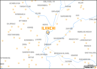
Īlkhchī (Ardabīl, Iran)Īlkhchī is a town in the Ardabīl region of Iran. An overview map of the region around Īlkhchī is displayed below.
regional and 3d topo map of Īlkhchī, Iran ::
Īlkhchī airports ::
The nearest airport is RAS - Rasht, located 125.9 km east of Īlkhchī.
Other airports nearby include TBZ - Tabriz Intl (184.6 km west), Nearby towns ::
Herīs (2.9km north) //
Yengejeh-ye Qeshlāq (3.5km west) //
Līkvān (4.3km south west) //
Sekarābād (4.3km south east) //
Qabākh (5.1km south) //
Mīkā'īlābād (4.7km south east) //
Seh Rāh-e Ganjgāh (4.9km north east) //
Babeh Jīk (5.1km south west) //
Fīrūzābād (5.7km south) //
Sa‘īdābād (5.3km east) //
Khalīfeh Chāy (6.9km south) //
Komoq (5.6km west) //
Nīlaq (7.6km north west) //
A‘z̧amābād (6.8km south west) //
Zenyāb (6.6km east) //
Ganjgāh (8.2km north) //
Sūreh Barq (8.0km north east) //
Zenāb (8.5km south west) //
Beneh Khalkhāl (9.4km south east) //
Pardastlū (8.9km north west) //
Sharafābād (10.1km south west) //
[all distances 'as the bird flies' and approximate] 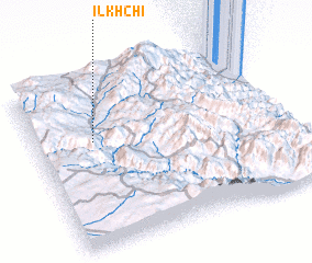 Places with similar names to Īlkhchī, Iran ::
// Ilʼkucha (UA)
Disclaimer :: Information on this page comes without warranty of any kind |
||
|
Where is Īlkhchī? Elevation and coordinates ::
Latitude (lat): 37°37'46"N Longitude (lon): 48°14'3"E
Elevation (approx.): 1178m (map arrows pan, magnifying glasses zoom) |
||
|
Visiting Īlkhchī? Hotel/Accommodation ::
Book a hotel in Īlkhchī Travel Guide ::
Buy a travel guide for Iran rental cars ::
car rental offers GPS waypoint ::
download a GPX waypoint (PoI) of Īlkhchī for your GPS receiver
|
||