|
search place name
|
||
Ja‘farābād (Eşfahān, Iran)Ja‘farābād is a town in the Eşfahān region of Iran. An overview map of the region around Ja‘farābād is displayed below.
regional and 3d topo map of Ja‘farābād, Iran ::
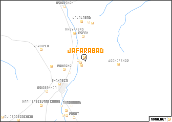
Nearby towns ::
Dowlatābād (1.1km south west) //
Manūchehrābād (1.3km south west) //
Bāgh-e Şādeqābād (1.4km west) //
Vāzhnān (3.0km north east) //
Shāhreẕā (3.9km south west) //
Rahnamā (4.4km south west) //
Esfeh (5.4km north) //
Kheyrābād (6.4km north) //
Jarm Afshār (6.2km east) //
Chaghān (6.4km west) //
Shahrezā (7.0km south west) //
Shāhzādeh Seyyed ‘Alī Akbar (8.3km north) //
Seyyedābād (8.5km north) //
Jalālābād (8.7km north) //
Āsīāb-e Khān (9.8km south west) //
[all distances 'as the bird flies' and approximate] 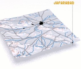 Places with similar names to Ja‘farābād, Iran ::
Disclaimer :: Information on this page comes without warranty of any kind |
||
|
Where is Ja‘farābād? Elevation and coordinates ::
Latitude (lat): 32°3'27"N Longitude (lon): 51°54'38"E
Elevation (approx.): 1777m (map arrows pan, magnifying glasses zoom) |
||
|
Visiting Ja‘farābād? Hotel/Accommodation ::
Book a hotel in Ja‘farābād Travel Guide ::
Buy a travel guide for Iran rental cars ::
car rental offers GPS waypoint ::
download a GPX waypoint (PoI) of Ja‘farābād for your GPS receiver
|
||