|
search place name
|
||
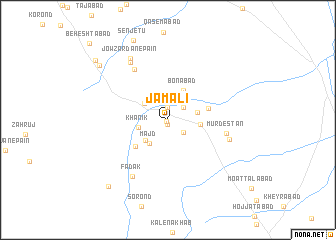
Jamālī (Khorāsān, Iran)Jamālī is a town in the Khorāsān region of Iran. An overview map of the region around Jamālī is displayed below.
regional and 3d topo map of Jamālī, Iran ::
Jamālī airports ::
The nearest airport is XBJ - Birjand, located 212.3 km south east of Jamālī.
Nearby towns ::
Raqeh (0.2km south west) //
Nowkhānīk (0.5km south) //
‘Alīābād (1.4km north) //
Deh Now (2.0km south east) //
Khorramābād (2.0km north east) //
Bīdak (2.8km north west) //
Majd (3.1km south west) //
Khānīk (2.8km west) //
Yegī (3.1km south west) //
Howgend (2.9km east) //
Zīrk (3.0km east) //
Bonābād (3.6km north east) //
Neygū (4.2km south west) //
Moḩammadābād (4.0km east) //
Murdestān (5.6km east) //
Jowzardān-e Bālā (6.5km north west) //
Bāgh-e Dehak (6.1km east) //
Fadak (7.1km south west) //
Jowzardān-e Meyānī (7.3km north west) //
Jowzardān-e Pā'īn (7.7km north west) //
Tajarg (8.8km north west) //
Khodā Āfarīd (9.3km south west) //
Jārestān (9.4km north west) //
Beheshtābād (11.2km north west) //
[all distances 'as the bird flies' and approximate] 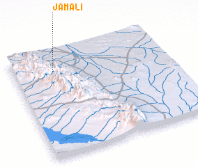 Places with similar names to Jamālī, Iran ::
Disclaimer :: Information on this page comes without warranty of any kind |
||
|
Where is Jamālī? Elevation and coordinates ::
Latitude (lat): 33°49'15"N Longitude (lon): 57°16'3"E
Elevation (approx.): 1182m (map arrows pan, magnifying glasses zoom) |
||
|
Visiting Jamālī? Hotel/Accommodation ::
Book a hotel in Jamālī Travel Guide ::
Buy a travel guide for Iran rental cars ::
car rental offers GPS waypoint ::
download a GPX waypoint (PoI) of Jamālī for your GPS receiver
|
||