|
search place name
|
||
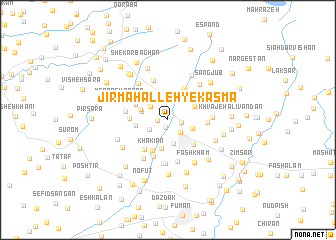
Jīr Maḩalleh-ye Kasmā' (Gīlān, Iran)Jīr Maḩalleh-ye Kasmā' is a town in the Gīlān region of Iran. An overview map of the region around Jīr Maḩalleh-ye Kasmā' is displayed below.
regional and 3d topo map of Jīr Maḩalleh-ye Kasmā', Iran ::
Jīr Maḩalleh-ye Kasmā' airports ::
The nearest airport is RAS - Rasht, located 27.3 km east of Jīr Maḩalleh-ye Kasmā'.
Other airports nearby include RZR - Ramsar (131.0 km east), Nearby towns ::
Qaşşāb Sarā (0.9km south) //
Kasmā' (0.9km west) //
Şeyqalān (1.3km east) //
‘Arabān (1.8km south east) //
Kherf (2.0km south west) //
Za‘fān (2.2km north west) //
Şowme‘eh Sarā (2.7km south) //
Eshpalam (2.4km south east) //
Jīrgūrāb (2.5km west) //
Pīshkhān (2.7km north east) //
Lādmakh (3.2km south) //
Shāram (2.7km north west) //
Dowhondeh (3.3km north west) //
Pāsgeh (2.9km west) //
Khākīān (3.7km south) //
Khaţībān (3.5km south east) //
Rāsteh Kenār (3.8km north) //
Pūstīn Sarā (3.4km north west) //
Ozgom (3.7km north east) //
Bālā Bowlgūr (3.9km south west) //
Pā'īn Bowlgūr (3.4km west) //
Bāgh Dasht (4.2km south) //
Kohnehsar (3.5km east) //
Zeydeh Sarā (4.7km south) //
Mīāndeh (4.6km north) //
Pardeh Sar (3.9km west) //
Māvardīān (4.8km south) //
Sīāh Pīrān-e Kasmā'ī (4.9km south) //
Kolkūh (4.0km east) //
[all distances 'as the bird flies' and approximate]  Places with similar names to Jīr Maḩalleh-ye Kasmā', Iran :: Disclaimer :: Information on this page comes without warranty of any kind |
||
|
Where is Jīr Maḩalleh-ye Kasmā'? Elevation and coordinates ::
Latitude (lat): 37°19'11"N Longitude (lon): 49°17'51"E
Elevation (approx.): -3m (map arrows pan, magnifying glasses zoom) |
||
|
Visiting Jīr Maḩalleh-ye Kasmā'? Hotel/Accommodation ::
Book a hotel in Jīr Maḩalleh-ye Kasmā' Travel Guide ::
Buy a travel guide for Iran rental cars ::
car rental offers GPS waypoint ::
download a GPX waypoint (PoI) of Jīr Maḩalleh-ye Kasmā' for your GPS receiver
|
||