|
search place name
|
||
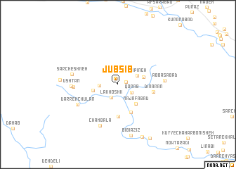
Jūb Sīb (Chahār Maḩāll va Bakhtīār, Iran)Jūb Sīb is a town in the Chahār Maḩāll va Bakhtīār region of Iran. An overview map of the region around Jūb Sīb is displayed below.
regional and 3d topo map of Jūb Sīb, Iran ::
Jūb Sīb airports ::
The nearest airport is QMJ - Masjed Soleiman Shahid Asyaee, located 103.6 km west of Jūb Sīb.
Other airports nearby include AWZ - Ahwaz (171.1 km south west), MRX - Bandar Mahshahr Mahshahr (201.4 km south west), Nearby towns ::
Cheshmeh Soleymān (1.1km east) //
Lākhoshk (2.3km south west) //
Qorāb (2.3km south east) //
Chahār Mūrān (2.5km west) //
Rūpīneh (3.0km north east) //
Chahārmūrān (3.5km west) //
Gerdopīneh (3.6km east) //
Najafābād (4.0km south east) //
Morādābād (4.7km south) //
Morādābād (5.1km south) //
Dīnārān (4.9km east) //
Lūshtar (6.0km west) //
Cham Balā (7.0km south) //
Darreh Chūlān (6.3km south west) //
Ūshtan (6.3km west) //
‘Abbāsābād (6.3km east) //
Sar Cheshmeh (6.4km west) //
Bībī ‘Azīz (8.3km south) //
‘Azīzābād-e Pā'īn (9.0km south) //
Azīz Ābād (9.6km south east) //
[all distances 'as the bird flies' and approximate] 
Disclaimer :: Information on this page comes without warranty of any kind |
||
|
Where is Jūb Sīb? Elevation and coordinates ::
Latitude (lat): 32°2'37"N Longitude (lon): 50°21'59"E
Elevation (approx.): 2092m (map arrows pan, magnifying glasses zoom) |
||
|
Visiting Jūb Sīb? Hotel/Accommodation ::
Book a hotel in Jūb Sīb Travel Guide ::
Buy a travel guide for Iran rental cars ::
car rental offers GPS waypoint ::
download a GPX waypoint (PoI) of Jūb Sīb for your GPS receiver
|
||