|
search place name
|
||
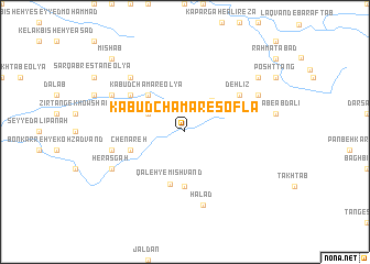
Kabūd Chamar-e Soflá (Lorestān, Iran)Kabūd Chamar-e Soflá is a town in the Lorestān region of Iran. An overview map of the region around Kabūd Chamar-e Soflá is displayed below.
regional and 3d topo map of Kabūd Chamar-e Soflá, Iran ::
Kabūd Chamar-e Soflá airports ::
The nearest airport is KSH - Bakhtaran Shahid Ashrafi Esfahani, located 158.6 km north west of Kabūd Chamar-e Soflá.
Other airports nearby include QMJ - Masjed Soleiman Shahid Asyaee (169.6 km south east), AWZ - Ahwaz (208.9 km south), Nearby towns ::
Bāgh Pīsh-e Bādāmak (3.6km north west) //
Āb Sard-e Dād Golāb (3.9km north east) //
Kabūd Chamar-e ‘Olyā (4.8km north west) //
Qal‘eh-ye Mīshvand (5.5km south) //
Qal‘eh-ye Mīshvand (5.6km south) //
Chenāreh (5.0km west) //
Deh Līz (6.0km north east) //
Dūlābī-ye Bādāmak (6.0km north west) //
Kūchemehr (6.0km north west) //
Chahār Dūlān (6.5km west) //
Ḩalad (7.6km south) //
Posht-e Zarrīn Choqā (7.3km north west) //
Zīr-e Zarrīn Choqā (7.2km north west) //
Herasgah (7.2km south west) //
Āb Sard-e Sarāb (7.2km north east) //
Darreh Shūreh (8.3km north east) //
Mīshāb (9.7km north west) //
[all distances 'as the bird flies' and approximate] 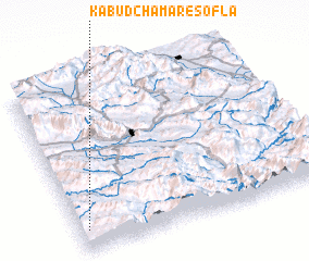 Places with similar names to Kabūd Chamar-e Soflá, Iran :: Disclaimer :: Information on this page comes without warranty of any kind |
||
|
Where is Kabūd Chamar-e Soflá? Elevation and coordinates ::
Latitude (lat): 33°7'0"N Longitude (lon): 48°2'0"E
Elevation (approx.): 1363m (map arrows pan, magnifying glasses zoom) |
||
|
Visiting Kabūd Chamar-e Soflá? Hotel/Accommodation ::
Book a hotel in Kabūd Chamar-e Soflá Travel Guide ::
Buy a travel guide for Iran rental cars ::
car rental offers GPS waypoint ::
download a GPX waypoint (PoI) of Kabūd Chamar-e Soflá for your GPS receiver
|
||