|
search place name
|
||
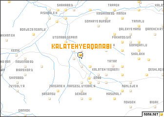
Kalāteh-ye Āqā Nabī (Khorāsān, Iran)Kalāteh-ye Āqā Nabī is a town in the Khorāsān region of Iran. An overview map of the region around Kalāteh-ye Āqā Nabī is displayed below.
regional and 3d topo map of Kalāteh-ye Āqā Nabī, Iran ::
Kalāteh-ye Āqā Nabī airports ::
The nearest airport is ASB - Ashkhabad Ashgabat, located 123.2 km north east of Kalāteh-ye Āqā Nabī.
Nearby towns ::
Kalāntar (1.9km north) //
Qal‘eh-ye Tāt (1.5km west) //
Barazānlū (1.9km south) //
Serīvān Tappeh (2.4km north west) //
Serīvān ‘Asheqān (2.4km north west) //
Qarājeh (2.4km south east) //
Badrānlū (4.7km south) //
Tāthā (4.7km south east) //
Ūterābād-e Bālā (4.7km north west) //
Ūterābād-e Pā'īn (4.7km north west) //
Kūrānlū (5.6km south) //
Sheykh Teymūrī (5.8km south) //
Dehgan (5.8km south) //
Qal‘eh-ye Tūt (5.8km south) //
Yengī Qal‘eh (4.8km north east) //
Cherrīk (4.8km north east) //
‘Arab (6.3km south east) //
Kalāteh-ye Qā‘enī (5.8km south east) //
Tātār (5.9km east) //
Nargeslū-ye Bālā (7.4km south) //
Golī (7.1km south east) //
Gomhā-ye Būr Būr (8.0km north) //
Būrbūr-e Tork (8.1km north east) //
Zangāneh (8.6km south west) //
Keykānlū (9.6km north west) //
[all distances 'as the bird flies' and approximate]  Places with similar names to Kalāteh-ye Āqā Nabī, Iran :: Disclaimer :: Information on this page comes without warranty of any kind |
||
|
Where is Kalāteh-ye Āqā Nabī? Elevation and coordinates ::
Latitude (lat): 37°34'0"N Longitude (lon): 57°4'0"E
Elevation (approx.): 868m (map arrows pan, magnifying glasses zoom) |
||
|
Visiting Kalāteh-ye Āqā Nabī? Hotel/Accommodation ::
Book a hotel in Kalāteh-ye Āqā Nabī Travel Guide ::
Buy a travel guide for Iran rental cars ::
car rental offers GPS waypoint ::
download a GPX waypoint (PoI) of Kalāteh-ye Āqā Nabī for your GPS receiver
|
||