|
search place name
|
||
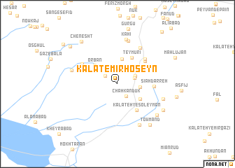
Kalāt-e Mīrḩoseyn (Khorāsān, Iran)Kalāt-e Mīrḩoseyn is a town in the Khorāsān region of Iran. An overview map of the region around Kalāt-e Mīrḩoseyn is displayed below.
regional and 3d topo map of Kalāt-e Mīrḩoseyn, Iran ::
Kalāt-e Mīrḩoseyn airports ::
The nearest airport is XBJ - Birjand, located 40.2 km north west of Kalāt-e Mīrḩoseyn.
Nearby towns ::
Qandāb (2.1km north west) //
Chahkandūk (2.3km south east) //
Rezq-e Soleymān (2.5km north east) //
Nūrollāh (2.7km north east) //
Hūk (3.1km east) //
Nīk (4.0km north) //
Kalāteh-ye Sheykh ‘Al (3.9km south east) //
‘Orbān (4.3km north west) //
Teymūrī (4.6km north east) //
Kalāteh-ye Soleymān (4.9km south east) //
Boghnag (5.2km north east) //
Kalāteh-ye ‘Alī (5.0km north east) //
Sīāh Darreh (5.0km east) //
Qūzg (5.5km north east) //
Deh-e Now (5.7km north west) //
Harīvand (6.5km north east) //
Ḩājjīābād (7.0km north) //
Kāhī (7.2km north) //
Moḩammadābād (7.2km south east) //
Bīd Meshk (6.5km west) //
Karīmābād (6.6km east) //
Sadīd (7.3km south east) //
Towmand (7.9km south east) //
Andemī (7.5km south east) //
Chenesht (8.3km north west) //
Gurgū (8.9km north) //
Eskūg Pā'īn (8.8km north west) //
Eskūk (9.6km north west) //
Shavākand (10.3km north east) //
[all distances 'as the bird flies' and approximate]  Places with similar names to Kalāt-e Mīrḩoseyn, Iran :: Disclaimer :: Information on this page comes without warranty of any kind |
||
|
Where is Kalāt-e Mīrḩoseyn? Elevation and coordinates ::
Latitude (lat): 32°34'17"N Longitude (lon): 59°27'3"E
Elevation (approx.): 2022m (map arrows pan, magnifying glasses zoom) |
||
|
Visiting Kalāt-e Mīrḩoseyn? Hotel/Accommodation ::
Book a hotel in Kalāt-e Mīrḩoseyn Travel Guide ::
Buy a travel guide for Iran rental cars ::
car rental offers GPS waypoint ::
download a GPX waypoint (PoI) of Kalāt-e Mīrḩoseyn for your GPS receiver
|
||