|
search place name
|
||
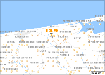
Kāleh (Iran)Kāleh is a town in Iran. An overview map of the region around Kāleh is displayed below.
regional and 3d topo map of Kāleh, Iran ::
Kāleh airports ::
The nearest airport is THR - Teheran Mehrabad Intl, located 170.3 km south west of Kāleh.
Nearby towns ::
‘Arab Kheyl (0.7km north east) //
Karīm Kolā (1.2km south) //
Tāzehābād (1.6km south west) //
Darāb Dīn-e Rowshan (1.9km south east) //
Ḩājjī Kolā-ye Behnemīr (1.9km south east) //
Bālā Afrā Takht (1.9km north east) //
Mīrūd (2.8km north) //
Kohneh Maḩalleh-ye Mīrūd (2.8km north) //
Ḩājjī Kolā (2.9km south east) //
Bahnemīr (3.0km south east) //
Gālesh-e Bālā (3.3km east) //
Halībāgh (3.3km east) //
Pā'īn Afrā Takht (3.3km east) //
Dārāb Dīn-e Bahnemīr (3.5km east) //
Shamsābād (3.9km south west) //
Afrātakht (4.2km north east) //
Pārū Maḩalleh-ye Mangelāb (4.9km south) //
Bālā Gālesh Kolā (4.9km south) //
Bālā Maḩalleh (4.9km south) //
Mangelāb (4.9km south) //
Rowshandān (4.4km south east) //
Bāqer Tangeh (4.4km west) //
Pā'īn Gālesh Kolā (5.5km south east) //
Sorkh Dasht (6.6km south) //
Gālesh Kolā-ye Pā'īn (6.6km south) //
‘Azīzak (6.5km south west) //
Eznābād (5.5km east) //
Khard Mard-e Anīsī (6.3km south west) //
Bālā Mīr Bāzār (6.3km south west) //
[all distances 'as the bird flies' and approximate]  Places with similar names to Kāleh, Iran ::
Disclaimer :: Information on this page comes without warranty of any kind |
||
|
Where is Kāleh? Elevation and coordinates ::
Latitude (lat): 36°41'28"N Longitude (lon): 52°44'53"E
Elevation (approx.): -20m (map arrows pan, magnifying glasses zoom) |
||
|
Visiting Kāleh? Hotel/Accommodation ::
Book a hotel in Kāleh Travel Guide ::
Buy a travel guide for Iran rental cars ::
car rental offers GPS waypoint ::
download a GPX waypoint (PoI) of Kāleh for your GPS receiver
|
||