|
search place name
|
||
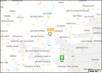
Kan (Tehrān, Iran)Kan is a town in the Tehrān region of Iran. An overview map of the region around Kan is displayed below.
regional and 3d topo map of Kan, Iran ::
Kan airports ::
The nearest airport is THR - Teheran Mehrabad Intl, located 8.5 km south east of Kan.
Other airports nearby include RZR - Ramsar (138.5 km north), RAS - Rasht (229.3 km north west), Nearby towns ::
Zībā Shahr (2.3km east) //
Shahrak-e Cheshmeh (3.7km south west) //
Ḩeşārak (4.3km north east) //
Qolhak Darreh (4.0km west) //
Bāgh-e Ladmāl (4.0km west) //
Ḩasanābād (4.6km south east) //
Bāgh-e Feyẕ (4.6km east) //
Morādābād (5.4km north east) //
Shahrak-e Ekbātān (6.0km south east) //
Jannatābād (6.0km south east) //
Keshār-e Pā'īn (6.3km north west) //
Pūnak (5.8km east) //
Sūleqān (7.2km north) //
Meydān-e Āzādī (7.0km south east) //
Keshār-e Bālā (7.4km north west) //
Shahrak-e Āzādī (7.5km south east) //
Tang-e Ābkhvor (7.0km north west) //
Qal‘eh-ye Soleymān Khānī (7.6km south west) //
Faraḩzād (7.0km north east) //
Shahrak-e Qods (6.7km east) //
Bāgh-e Anārī (6.9km west) //
Shahrak-e Daryā (8.8km south) //
Āb-e Zendegānī (8.2km north east) //
Ţarasht (8.4km south east) //
Jey (10.7km south east) //
[all distances 'as the bird flies' and approximate] 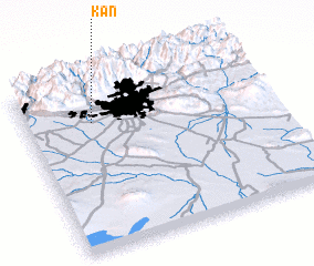 Places with similar names to Kan, Iran ::
Disclaimer :: Information on this page comes without warranty of any kind |
||
|
Where is Kan? Elevation and coordinates ::
Latitude (lat): 35°45'33"N Longitude (lon): 51°16'35"E
Elevation (approx.): 1381m (map arrows pan, magnifying glasses zoom) |
||
|
Visiting Kan? Hotel/Accommodation ::
Book a hotel in Kan Travel Guide ::
Buy a travel guide for Iran rental cars ::
car rental offers GPS waypoint ::
download a GPX waypoint (PoI) of Kan for your GPS receiver
|
||