|
search place name
|
||
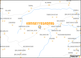
Kānī Seyyed Morād (Kordestān, Iran)Kānī Seyyed Morād is a town in the Kordestān region of Iran. An overview map of the region around Kānī Seyyed Morād is displayed below.
regional and 3d topo map of Kānī Seyyed Morād, Iran ::
Kānī Seyyed Morād airports ::
The nearest airport is SDG - Sanandaj, located 69.3 km south of Kānī Seyyed Morād.
Other airports nearby include KSH - Bakhtaran Shahid Ashrafi Esfahani (169.8 km south), Nearby towns ::
Mareh Darreh (1.5km east) //
Havās Beyk (2.4km south west) //
Na‘l Shekan (4.0km south) //
Qal‘eh Gāh (3.5km north east) //
Sheykh Laţīf (3.5km south west) //
Ḩoseynābād (6.0km east) //
Darreh Dūzān (6.0km west) //
Darreh Vīān (6.3km east) //
Bardeh Rash (6.3km west) //
Tabrīz Khātūn (7.2km north east) //
Mīshāb (7.2km south east) //
Sang-e Sefīd (7.1km south east) //
Bardrash (8.2km north east) //
Sharīfābād (9.4km north west) //
[all distances 'as the bird flies' and approximate] 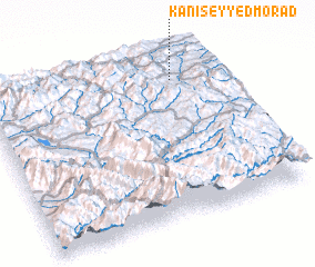 Places with similar names to Kānī Seyyed Morād, Iran :: Disclaimer :: Information on this page comes without warranty of any kind |
||
|
Where is Kānī Seyyed Morād? Elevation and coordinates ::
Latitude (lat): 35°51'0"N Longitude (lon): 46°49'0"E
Elevation (approx.): 2036m (map arrows pan, magnifying glasses zoom) |
||
|
Visiting Kānī Seyyed Morād? Hotel/Accommodation ::
Book a hotel in Kānī Seyyed Morād Travel Guide ::
Buy a travel guide for Iran rental cars ::
car rental offers GPS waypoint ::
download a GPX waypoint (PoI) of Kānī Seyyed Morād for your GPS receiver
|
||