|
search place name
|
||
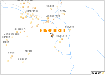
Kāshparkān (Hormozgān, Iran)Kāshparkān is a town in the Hormozgān region of Iran. An overview map of the region around Kāshparkān is displayed below.
regional and 3d topo map of Kāshparkān, Iran ::
Kāshparkān airports ::
The nearest airport is BND - Bandar Abbass Intl, located 79.7 km south west of Kāshparkān.
Other airports nearby include KHS - Khasab (193.6 km south), BDH - Bandar Lengeh (240.5 km south west), Nearby towns ::
Balm-e Sagī (2.9km south east) //
Gerdekān-e Aḩmadī (3.4km south) //
Kolūchān (3.1km east) //
Zamīn-e Sīāh (5.3km north) //
Pā Zard (5.3km south) //
Ḩeydarābād (5.6km north) //
Gerū'īyeh (6.1km north) //
Bīsheh (6.0km north west) //
Jalālī (6.2km north) //
Serāh-e Aḩmadī (6.6km north) //
Parkān (6.6km north) //
Shaqrūd (6.2km north east) //
Mīrābād (6.4km north west) //
Kharā'ī-ye Pā'īn (6.5km north west) //
Qalam (7.1km north) //
Dar Qu'īyeh (7.9km north west) //
Mazra‘eh (7.9km north west) //
Farzāmābād (7.6km north west) //
Kharā'ī-ye Bālā (8.5km north west) //
Deh Moghān (9.1km north) //
Serāj (9.1km north east) //
Kahnūj-e Aḩmadkhānī (8.9km north west) //
Dar Kherāʼī (8.6km north west) //
Qolī (9.0km north west) //
Tīdemeh (9.0km north west) //
Kahnūj-e Moḩammad ‘Alīkhānī (9.0km north west) //
Sarā-ye Aḩmadī (9.7km north west) //
Sarkam (9.5km south west) //
Barrūd (10.2km north west) //
[all distances 'as the bird flies' and approximate]  Places with similar names to Kāshparkān, Iran :: Disclaimer :: Information on this page comes without warranty of any kind |
||
|
Where is Kāshparkān? Elevation and coordinates ::
Latitude (lat): 27°51'30"N Longitude (lon): 56°44'48"E
Elevation (approx.): 842m (map arrows pan, magnifying glasses zoom) |
||
|
Visiting Kāshparkān? Hotel/Accommodation ::
Book a hotel in Kāshparkān Travel Guide ::
Buy a travel guide for Iran rental cars ::
car rental offers GPS waypoint ::
download a GPX waypoint (PoI) of Kāshparkān for your GPS receiver
|
||