|
search place name
|
||
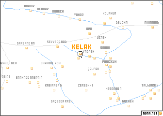
Kelāk (Tehrān, Iran)Kelāk is a town in the Tehrān region of Iran. An overview map of the region around Kelāk is displayed below.
regional and 3d topo map of Kelāk, Iran ::
Kelāk airports ::
The nearest airport is THR - Teheran Mehrabad Intl, located 100.8 km west of Kelāk.
Other airports nearby include RZR - Ramsar (212.4 km north west), Nearby towns ::
Badreh (0.6km west) //
Yadreh (1.5km east) //
Andar Āb (2.4km east) //
Nadarāb (2.4km east) //
Qalfak (4.5km south east) //
Saqqez Darreh (4.1km south west) //
Şanam (4.8km east) //
Mashhad (4.9km east) //
Ārū (5.8km north) //
Ūzneh (5.4km north east) //
Seyyedābād (5.2km north west) //
Chaman (5.6km south east) //
Rūd Afshān (5.4km east) //
Fīrūz Kūh (5.8km east) //
Sorkheh (6.1km south east) //
Shāh Bolāghī (6.0km west) //
Qolqolak (6.4km south west) //
Zereshkī (7.5km south) //
Govīch (6.9km south west) //
Yahar (8.8km north) //
Kohnak (9.1km north east) //
Kabīrābād (9.1km south west) //
Ḩeşār Bon (10.3km south east) //
[all distances 'as the bird flies' and approximate]  Places with similar names to Kelāk, Iran ::
Disclaimer :: Information on this page comes without warranty of any kind |
||
|
Where is Kelāk? Elevation and coordinates ::
Latitude (lat): 35°37'2"N Longitude (lon): 52°25'24"E
Elevation (approx.): 1890m (map arrows pan, magnifying glasses zoom) |
||
|
Visiting Kelāk? Hotel/Accommodation ::
Book a hotel in Kelāk Travel Guide ::
Buy a travel guide for Iran rental cars ::
car rental offers GPS waypoint ::
download a GPX waypoint (PoI) of Kelāk for your GPS receiver
|
||