|
search place name
|
||
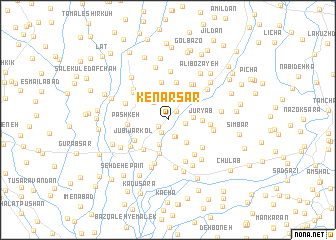
Kenār Sar (Gīlān, Iran)Kenār Sar is a town in the Gīlān region of Iran. An overview map of the region around Kenār Sar is displayed below.
regional and 3d topo map of Kenār Sar, Iran ::
Kenār Sar airports ::
The nearest airport is RAS - Rasht, located 17.0 km west of Kenār Sar.
Other airports nearby include RZR - Ramsar (90.2 km south east), THR - Teheran Mehrabad Intl (225.4 km south east), Nearby towns ::
Līmū Chāh (1.2km north east) //
Garākū (1.2km south west) //
Gīlovā Bālā Maḩalleh (1.5km south) //
Gīlovā Dashtān (1.9km south) //
Gavshā (1.6km east) //
Dashnān (1.9km south) //
‘Alī Nowdeh (2.4km north west) //
Māmūdān (2.3km east) //
Garbāsdeh (2.9km south) //
Chalakdān (3.0km south east) //
Bālā Gafsheh (3.2km north east) //
Lāleh Gafsheh (3.2km north east) //
Hendavāneh-ye Pordesar (3.8km south) //
Jūryāb (3.1km east) //
Kūcheşfahān (3.9km south west) //
Kālmarz (4.2km north) //
Shīrāyeh (4.3km north) //
Jūbījārkol (3.8km south west) //
Pashkeh (3.6km west) //
Pas Bījār Gafsheh (4.4km north east) //
Gīlovā Khālakī (3.8km east) //
Chelak (4.4km south east) //
Ḩājjī Bozāyeh (4.6km north east) //
Yūsefābād (4.3km north west) //
Ţārom Sar (4.3km south east) //
Rūdbārakī (4.9km south) //
Rūdkol (5.0km south) //
Lāleh Dasht (4.4km south west) //
Khesht-e Masjed (4.2km north west) //
[all distances 'as the bird flies' and approximate]  Places with similar names to Kenār Sar, Iran :: Disclaimer :: Information on this page comes without warranty of any kind |
||
|
Where is Kenār Sar? Elevation and coordinates ::
Latitude (lat): 37°18'37"N Longitude (lon): 49°47'48"E
Elevation (approx.): -10m (map arrows pan, magnifying glasses zoom) |
||
|
Visiting Kenār Sar? Hotel/Accommodation ::
Book a hotel in Kenār Sar Travel Guide ::
Buy a travel guide for Iran rental cars ::
car rental offers GPS waypoint ::
download a GPX waypoint (PoI) of Kenār Sar for your GPS receiver
|
||