|
search place name
|
||
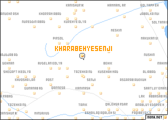
Kharābeh-ye Senjī (Ostān-e Āz̄arbāyjān-e Gharbī, Iran)Kharābeh-ye Senjī is a town in the Ostān-e Āz̄arbāyjān-e Gharbī region of Iran. An overview map of the region around Kharābeh-ye Senjī is displayed below.
regional and 3d topo map of Kharābeh-ye Senjī, Iran ::
Kharābeh-ye Senjī airports ::
The nearest airport is TBZ - Tabriz Intl, located 123.6 km east of Kharābeh-ye Senjī.
Other airports nearby include VAN - Van (157.1 km north west), Nearby towns ::
Īshgeh Sū (3.6km south) //
Tāzeh Kand (3.7km south) //
Khalyān (3.5km south west) //
Kānesbī (4.7km south west) //
Meshīk (4.7km north west) //
Āvdelān-e Soflá (4.8km south west) //
Behīk (4.8km south east) //
Cher (4.8km north east) //
Senjī (5.7km south) //
Kūseh Aḩmad (5.7km south east) //
Pīrgol (5.7km north west) //
Kānī Rash (7.4km south) //
Āvdelān-e ‘Olyā (6.1km west) //
Qareh Āghāj (6.1km west) //
Kūreh-yeSoflá (7.6km north) //
Kūreh-ye ‘Olyā (7.6km north) //
Ḩeşār Kharābeh (8.0km south) //
Qarnesā' (8.6km south west) //
Meskīn (8.1km north east) //
Delādar (8.6km north west) //
Eshgehsū (8.1km south west) //
Post (8.1km south west) //
[all distances 'as the bird flies' and approximate] 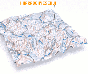 Places with similar names to Kharābeh-ye Senjī, Iran :: Disclaimer :: Information on this page comes without warranty of any kind |
||
|
Where is Kharābeh-ye Senjī? Elevation and coordinates ::
Latitude (lat): 37°47'0"N Longitude (lon): 44°54'0"E
Elevation (approx.): 1731m (map arrows pan, magnifying glasses zoom) |
||
|
Visiting Kharābeh-ye Senjī? Hotel/Accommodation ::
Book a hotel in Kharābeh-ye Senjī Travel Guide ::
Buy a travel guide for Iran rental cars ::
car rental offers GPS waypoint ::
download a GPX waypoint (PoI) of Kharābeh-ye Senjī for your GPS receiver
|
||