|
search place name
|
||
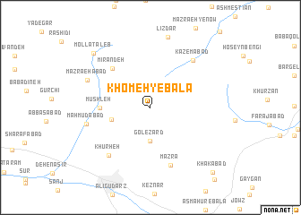
Khomeh-ye Bālā (Lorestān, Iran)Khomeh-ye Bālā is a town in the Lorestān region of Iran. An overview map of the region around Khomeh-ye Bālā is displayed below.
regional and 3d topo map of Khomeh-ye Bālā, Iran ::
Khomeh-ye Bālā airports ::
The nearest airport is QMJ - Masjed Soleiman Shahid Asyaee, located 169.8 km south of Khomeh-ye Bālā.
Nearby towns ::
Gol-e Zard (4.2km south) //
Darreh Ḩeydar (4.0km north west) //
Khomeh-ye Pāʼīn (4.3km west) //
Mūshleh (5.3km west) //
Kondor (6.3km north west) //
Mīrāndeh (6.3km north west) //
Mazrā‘ (7.5km south) //
Kāz̧emābād (7.3km north east) //
Khūrheh (7.4km south west) //
Maḩmūdābād (6.9km west) //
Mazra‘ehābād (7.4km north west) //
Līzdar (8.9km north) //
Mollā Ţāleb (9.0km north west) //
Khākābād (10.3km south east) //
[all distances 'as the bird flies' and approximate] 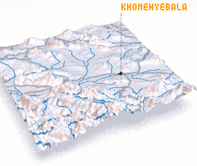 Places with similar names to Khomeh-ye Bālā, Iran :: Disclaimer :: Information on this page comes without warranty of any kind |
||
|
Where is Khomeh-ye Bālā? Elevation and coordinates ::
Latitude (lat): 33°28'53"N Longitude (lon): 49°44'19"E
Elevation (approx.): 2150m (map arrows pan, magnifying glasses zoom) |
||
|
Visiting Khomeh-ye Bālā? Hotel/Accommodation ::
Book a hotel in Khomeh-ye Bālā Travel Guide ::
Buy a travel guide for Iran rental cars ::
car rental offers GPS waypoint ::
download a GPX waypoint (PoI) of Khomeh-ye Bālā for your GPS receiver
|
||