|
search place name
|
||
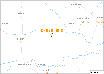
Khūshānak (Sīstān va Balūchestān, Iran)Khūshānak is a town in the Sīstān va Balūchestān region of Iran. An overview map of the region around Khūshānak is displayed below.
regional and 3d topo map of Khūshānak, Iran ::
Khūshānak airports ::
The nearest airport is TRB - Turbo Turbat Intl, located 139.6 km south east of Khūshānak.
Other airports nearby include PJG - Panjgur (168.1 km east), GWD - Gwadar (210.8 km south), PSI - Pasni (222.9 km south east), Nearby towns ::
Shānd (7.6km north east) //
[all distances 'as the bird flies' and approximate]  Places with similar names to Khūshānak, Iran ::
// Khushenga (RU)
// Khiching (IN)
// Khoshnag (IR)
// Khashang (PK)
// Khushang (PK)
// Qhuishuanca (PE)
// Kao-ho-ch'eng (TW)
// Khê Chung (VN)
// Khê Chuồng (VN)
// Caohecheng (CN)
Disclaimer :: Information on this page comes without warranty of any kind |
||
|
Where is Khūshānak? Elevation and coordinates ::
Latitude (lat): 27°8'0"N Longitude (lon): 62°27'0"E
Elevation (approx.): 1069m (map arrows pan, magnifying glasses zoom) |
||
|
Visiting Khūshānak? Hotel/Accommodation ::
Book a hotel in Khūshānak Travel Guide ::
Buy a travel guide for Iran rental cars ::
car rental offers GPS waypoint ::
download a GPX waypoint (PoI) of Khūshānak for your GPS receiver
|
||