|
search place name
|
||
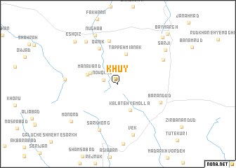
Khūy (Khorāsān, Iran)Khūy is a town in the Khorāsān region of Iran. An overview map of the region around Khūy is displayed below.
regional and 3d topo map of Khūy, Iran ::
Khūy airports ::
The nearest airport is XBJ - Birjand, located 58.7 km south west of Khūy.
Nearby towns ::
Now Qand (2.0km west) //
Kalāteh-ye Mollā (4.5km south) //
Manāvand (4.0km north west) //
Tappeh Mīānak (4.8km north) //
Māsnān (4.3km west) //
Ownīk (6.1km north west) //
Kūh-e Taq-e Mangī (6.9km north) //
Bar Andūd (6.4km south east) //
Sar Khong (7.8km south) //
Shīrk (7.1km north east) //
Vek (8.3km south) //
Qolleh-ye Derakhtūn (8.0km north west) //
Kūh-e Moḩammad Ḩoseyn-e ‘Abedī (7.1km west) //
Nūghāb (8.3km north) //
Sārjī (8.3km north east) //
Monond (8.6km south west) //
‘Eshqīz (8.9km north west) //
Kalāteh-ye Mazār (9.5km north east) //
Bāymargh (10.3km north east) //
[all distances 'as the bird flies' and approximate] 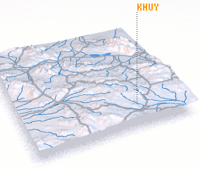 Places with similar names to Khūy, Iran ::
Disclaimer :: Information on this page comes without warranty of any kind |
||
|
Where is Khūy? Elevation and coordinates ::
Latitude (lat): 33°15'21"N Longitude (lon): 59°43'44"E
Elevation (approx.): 2170m (map arrows pan, magnifying glasses zoom) |
||
|
Visiting Khūy? Hotel/Accommodation ::
Book a hotel in Khūy Travel Guide ::
Buy a travel guide for Iran rental cars ::
car rental offers GPS waypoint ::
download a GPX waypoint (PoI) of Khūy for your GPS receiver
|
||