|
search place name
|
||
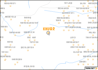
Khvar (Kermān, Iran)Khvar is a town in the Kermān region of Iran. An overview map of the region around Khvar is displayed below.
regional and 3d topo map of Khvar, Iran ::
Khvar airports ::
The nearest airport is RAS - Rasht, located 127.1 km south east of Khvar.
Other airports nearby include RZR - Ramsar (227.2 km south east), Nearby towns ::
Garūf-e Vīznah (4.7km north east) //
Meskīn-e Vīznah (4.7km north east) //
Qāchāgham Kūh (4.7km south west) //
Ḩūr (4.7km south west) //
Sūhā (5.5km north east) //
Tefeyeh (5.7km south west) //
Saqqezchī (5.8km west) //
Lūshakī-ye Vīznah (6.1km east) //
Sardāhūnī-ye Vīznah (6.1km east) //
Raz (6.1km west) //
Maḩmūdābād (7.1km north east) //
Govāndsar-e Vīznah (6.9km north east) //
Tappeh Gūrestān (6.9km north west) //
Ālādīzgeh (8.6km north east) //
Gūnesh (8.6km north east) //
Kolambī (8.1km north east) //
Nīāraq (8.4km north west) //
Qezel Qayeh (8.6km south west) //
Shīrī Ḩayāţī (9.4km north east) //
[all distances 'as the bird flies' and approximate] 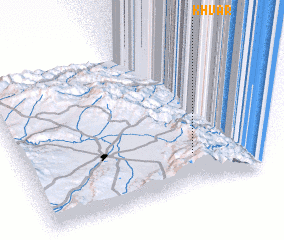 Places with similar names to Khvar, Iran ::
Disclaimer :: Information on this page comes without warranty of any kind |
||
|
Where is Khvar? Elevation and coordinates ::
Latitude (lat): 38°13'0"N Longitude (lon): 48°42'0"E
Elevation (approx.): 1932m (map arrows pan, magnifying glasses zoom) |
||
|
Visiting Khvar? Hotel/Accommodation ::
Book a hotel in Khvar Travel Guide ::
Buy a travel guide for Iran rental cars ::
car rental offers GPS waypoint ::
download a GPX waypoint (PoI) of Khvar for your GPS receiver
|
||