|
search place name
|
||
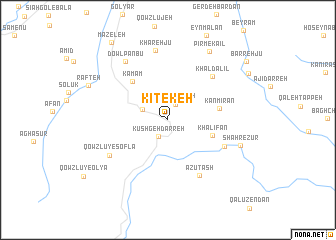
Kītekeh (Ostān-e Āz̄arbāyjān-e Gharbī, Iran)Kītekeh is a town in the Ostān-e Āz̄arbāyjān-e Gharbī region of Iran. An overview map of the region around Kītekeh is displayed below.
regional and 3d topo map of Kītekeh, Iran ::
Kītekeh airports ::
The nearest airport is SDG - Sanandaj, located 181.5 km south east of Kītekeh.
Other airports nearby include TBZ - Tabriz Intl (184.0 km north), Nearby towns ::
Qal‘eh Jūqeh (1.9km north) //
Kūshgeh Darreh (2.0km south west) //
Ganehdār (2.6km north west) //
Khalīfān (4.3km south east) //
Kāmam (5.4km north west) //
Kān Mīrān (4.8km east) //
Khāl Dalīl (6.3km north east) //
Qūyţāl (5.9km south east) //
Azūtāsh (6.8km south east) //
Qowzlū-ye Soflá (6.6km south west) //
Kharehjū (7.8km north) //
Dowlpanbū (7.5km north west) //
Shahr-e Zūr (7.1km south east) //
Pīr Mekā'īl (8.5km north east) //
Rafteh (8.1km north west) //
Māzeleh (10.0km north west) //
Barreh Jū (9.6km north east) //
[all distances 'as the bird flies' and approximate] 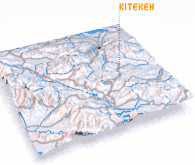 Places with similar names to Kītekeh, Iran ::
Disclaimer :: Information on this page comes without warranty of any kind |
||
|
Where is Kītekeh? Elevation and coordinates ::
Latitude (lat): 36°31'19"N Longitude (lon): 45°45'7"E
Elevation (approx.): 1507m (map arrows pan, magnifying glasses zoom) |
||
|
Visiting Kītekeh? Hotel/Accommodation ::
Book a hotel in Kītekeh Travel Guide ::
Buy a travel guide for Iran rental cars ::
car rental offers GPS waypoint ::
download a GPX waypoint (PoI) of Kītekeh for your GPS receiver
|
||