|
search place name
|
||
Koshteh (Hormozgān, Iran)Koshteh is a town in the Hormozgān region of Iran. An overview map of the region around Koshteh is displayed below.
regional and 3d topo map of Koshteh, Iran ::

Koshteh airports ::
The nearest airport is BND - Bandar Abbass Intl, located 49.2 km south west of Koshteh.
Other airports nearby include KHS - Khasab (156.1 km south), BDH - Bandar Lengeh (220.2 km south west), RKT - Ras Al Khaimah Intl (224.5 km south), Nearby towns ::
Sark (1.4km south) //
Zohūkī (1.5km south east) //
Chāhestān (4.7km west) //
Gordū (5.1km south east) //
Gaz Shahnīyeh (5.0km east) //
Seyyedābād (5.5km south west) //
Sar Şamad (6.3km east) //
Kherd-e Now (6.8km south west) //
Bohregh (6.9km north west) //
Sarsomāt (7.1km south east) //
Bālūlī (7.0km east) //
Gonbad-e Sorkh (8.1km south) //
Poshtū'ī (8.0km north west) //
Nīān (7.7km north east) //
Kashkū'īyeh (8.6km south) //
Sarīk (7.7km east) //
Chāh ‘Ālī (8.7km south) //
Nīān (8.7km north east) //
Āb Pīsh (8.9km south west) //
[all distances 'as the bird flies' and approximate] 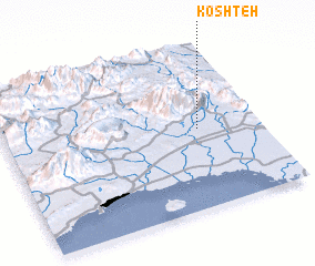 Places with similar names to Koshteh, Iran ::
Disclaimer :: Information on this page comes without warranty of any kind |
||
|
Where is Koshteh? Elevation and coordinates ::
Latitude (lat): 27°29'58"N Longitude (lon): 56°45'45"E
Elevation (approx.): 45m (map arrows pan, magnifying glasses zoom) |
||
|
Visiting Koshteh? Hotel/Accommodation ::
Book a hotel in Koshteh Travel Guide ::
Buy a travel guide for Iran rental cars ::
car rental offers GPS waypoint ::
download a GPX waypoint (PoI) of Koshteh for your GPS receiver
|
||