|
search place name
|
||
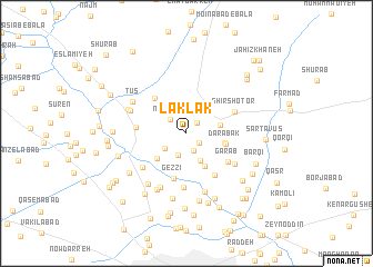
Laklak (Khorāsān, Iran)Laklak is a town in the Khorāsān region of Iran. An overview map of the region around Laklak is displayed below.
regional and 3d topo map of Laklak, Iran ::
Laklak airports ::
The nearest airport is ASB - Ashkhabad Ashgabat, located 206.0 km north west of Laklak.
Nearby towns ::
Kālākūb (1.4km north east) //
Khorramābād (1.4km south east) //
Bāgh-e Farhād Gerd (1.8km south) //
Now Chāh (2.0km north west) //
Bahār (2.3km south) //
Kalāteh-ye Qāẕī (2.3km south west) //
Kholqābād (2.9km south) //
Farokhod (2.9km east) //
Rowghangarān (3.7km south east) //
Ḩasan Shahāb (3.4km south west) //
Dārābād-e Khazāneh (3.2km east) //
Darābak (3.3km east) //
Gezzī (4.7km south) //
Gonbadvāz (4.4km north west) //
Garāb (4.4km south east) //
Shāyeh (4.8km south east) //
Malekābād (4.2km west) //
Shīr Shotor (4.4km north east) //
Rūd-e Khīn (5.4km south) //
Sākhtemān (4.9km south west) //
Darbābād-e Shāzdeh (5.0km south east) //
Ferīzī (5.8km south) //
Kalāteh-ye Teymūrī (5.1km north west) //
Kāz̧emābād-e Panj Shanbeh (6.1km south) //
Arband (5.9km south west) //
Ţūs (5.4km north west) //
Amerqān-e Ţūs (5.3km north west) //
Ebrāhīmābād (6.1km south west) //
Khīn-e ‘Arab (6.6km south) //
[all distances 'as the bird flies' and approximate] 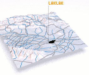 Places with similar names to Laklak, Iran ::
Disclaimer :: Information on this page comes without warranty of any kind |
||
|
Where is Laklak? Elevation and coordinates ::
Latitude (lat): 36°25'32"N Longitude (lon): 59°36'58"E
Elevation (approx.): 994m (map arrows pan, magnifying glasses zoom) |
||
|
Visiting Laklak? Hotel/Accommodation ::
Book a hotel in Laklak Travel Guide ::
Buy a travel guide for Iran rental cars ::
car rental offers GPS waypoint ::
download a GPX waypoint (PoI) of Laklak for your GPS receiver
|
||