|
search place name
|
||
Latīfābād (Khorāsān, Iran)Latīfābād is a town in the Khorāsān region of Iran. An overview map of the region around Latīfābād is displayed below.
regional and 3d topo map of Latīfābād, Iran ::
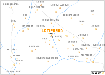
Nearby towns ::
Rīvand (1.0km north) //
Golestān (1.3km south west) //
Kāz̧emābād (1.8km north west) //
Ḩarnīq (2.1km south east) //
Bīdābād (2.5km south) //
Sa‘dū (2.5km south west) //
Khowjeh Beyg (3.4km south) //
Dowlatābād (3.0km north east) //
Qalandarābād (4.1km east) //
Nūrābād (4.5km north west) //
Ja‘farābād (4.2km east) //
‘Abbāsābād-e ‘Amīdī (5.2km north) //
Bāzeh-ye ‘Āsheqān (6.0km south east) //
Pay Godar (6.7km south west) //
Rūd Khar (6.4km east) //
Sar Āsīāb (6.7km south east) //
Pay Godar (7.6km south west) //
Qal‘eh-ye Ḩeydarābād (8.7km south) //
Ḩasanābād (7.7km west) //
‘Alīābād-e Dāman (8.8km north east) //
Reẕāābād (10.1km south east) //
Khānīk (10.1km south east) //
[all distances 'as the bird flies' and approximate] 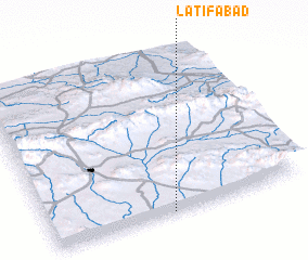 Places with similar names to Latīfābād, Iran ::
Disclaimer :: Information on this page comes without warranty of any kind |
||
|
Where is Latīfābād? Elevation and coordinates ::
Latitude (lat): 35°0'36"N Longitude (lon): 59°28'26"E
Elevation (approx.): 1126m (map arrows pan, magnifying glasses zoom) |
||
|
Visiting Latīfābād? Hotel/Accommodation ::
Book a hotel in Latīfābād Travel Guide ::
Buy a travel guide for Iran rental cars ::
car rental offers GPS waypoint ::
download a GPX waypoint (PoI) of Latīfābād for your GPS receiver
|
||