|
search place name
|
||
Lā-ye Khorramī (Fārs, Iran)Lā-ye Khorramī is a town in the Fārs region of Iran. An overview map of the region around Lā-ye Khorramī is displayed below.
regional and 3d topo map of Lā-ye Khorramī, Iran ::

Lā-ye Khorramī airports ::
The nearest airport is SYZ - Shiraz Shahid Dastghaib Intl, located 129.0 km west of Lā-ye Khorramī.
Nearby towns ::
Anjīrak (1.5km south) //
Yūrd-e Now (2.0km north east) //
Mobārakābād (2.5km north east) //
Ḩoseynābād (2.5km north east) //
Elāhābād (2.8km north east) //
Dāmaneh (3.2km north east) //
Davāneh (3.2km north east) //
Tolombeh-ye Nīshahr (3.7km south west) //
Dar Bandān (4.7km north) //
Gordeh (5.5km south) //
Sūn (5.1km north east) //
Sahlābād (6.1km north east) //
Māh Farrokhān (6.3km north east) //
Mīāndeh-e Sūn (6.8km north east) //
Tājābād (6.7km west) //
Banavān (8.2km north east) //
Dastjerd (9.0km north east) //
Dehūyeh (9.4km north east) //
[all distances 'as the bird flies' and approximate] 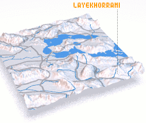 Places with similar names to Lā-ye Khorramī, Iran :: Disclaimer :: Information on this page comes without warranty of any kind |
||
|
Where is Lā-ye Khorramī? Elevation and coordinates ::
Latitude (lat): 29°12'34"N Longitude (lon): 53°51'52"E
Elevation (approx.): 1637m (map arrows pan, magnifying glasses zoom) |
||
|
Visiting Lā-ye Khorramī? Hotel/Accommodation ::
Book a hotel in Lā-ye Khorramī Travel Guide ::
Buy a travel guide for Iran rental cars ::
car rental offers GPS waypoint ::
download a GPX waypoint (PoI) of Lā-ye Khorramī for your GPS receiver
|
||