|
search place name
|
||
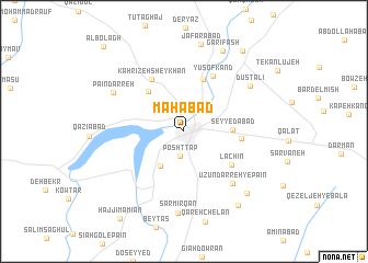
Mahābād (Ostān-e Āz̄arbāyjān-e Gharbī, Iran)Mahābād is a town in the Ostān-e Āz̄arbāyjān-e Gharbī region of Iran. An overview map of the region around Mahābād is displayed below.
regional and 3d topo map of Mahābād, Iran ::
Mahābād airports ::
The nearest airport is TBZ - Tabriz Intl, located 158.6 km north of Mahābād.
Other airports nearby include SDG - Sanandaj (204.6 km south east), Nearby towns ::
Posht Tap (2.5km south) //
Ḩamzehābād (4.0km south west) //
Seyyedābād (4.0km east) //
Kūh-e Khalveh (5.0km north west) //
Khāneqāh (5.5km north) //
Pīr Balen (4.8km east) //
Lāchīn (5.2km south east) //
Kahrīzeh Sheykhān (6.0km north west) //
Yūsof Kand (6.1km north) //
Ūzūn Darreh-ye Pāʼīn (6.7km south east) //
Dūst ‘Alī (7.1km north east) //
Pā'īn Darreh (7.0km north west) //
Sar Mīrqān (8.3km south) //
Ja‘farābād (8.9km north) //
Kohneh Deh (8.2km south east) //
Garīfāsh (8.8km north) //
Ūzūn Darreh-ye Bālā (8.7km south east) //
Andarqāsh (9.6km north east) //
Ḩājjī Mā Mīān (10.3km south west) //
Āl Bolāgh (10.9km north west) //
[all distances 'as the bird flies' and approximate]  Places with similar names to Mahābād, Iran ::
Disclaimer :: Information on this page comes without warranty of any kind |
||
|
Where is Mahābād? Elevation and coordinates ::
Latitude (lat): 36°45'53"N Longitude (lon): 45°43'18"E
Elevation (approx.): 1324m (map arrows pan, magnifying glasses zoom) |
||
|
Visiting Mahābād? Hotel/Accommodation ::
Book a hotel in Mahābād Travel Guide ::
Buy a travel guide for Iran rental cars ::
car rental offers GPS waypoint ::
download a GPX waypoint (PoI) of Mahābād for your GPS receiver
|
||