|
search place name
|
||
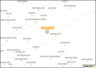
Mahbār (Hamadān, Iran)Mahbār is a town in the Hamadān region of Iran. An overview map of the region around Mahbār is displayed below.
regional and 3d topo map of Mahbār, Iran ::
Mahbār airports ::
The nearest airport is KSH - Bakhtaran Shahid Ashrafi Esfahani, located 162.2 km west of Mahbār.
Other airports nearby include SDG - Sanandaj (169.0 km west), Nearby towns ::
Gonbad Chāy (2.7km east) //
Sabzābād (5.9km north west) //
Gūr Goz (6.5km north) //
Āqjeh Kharābeh-ye Pāʼīn (6.3km north west) //
‘Arablū (7.1km south west) //
Tāḩūnābād (6.9km south east) //
Shīrābād (7.2km south west) //
Ḩeyrān (9.0km south east) //
Āq Dāsh (9.1km north west) //
[all distances 'as the bird flies' and approximate]  Places with similar names to Mahbār, Iran ::
Disclaimer :: Information on this page comes without warranty of any kind |
||
|
Where is Mahbār? Elevation and coordinates ::
Latitude (lat): 34°52'30"N Longitude (lon): 48°48'23"E
Elevation (approx.): 1943m (map arrows pan, magnifying glasses zoom) |
||
|
Visiting Mahbār? Hotel/Accommodation ::
Book a hotel in Mahbār Travel Guide ::
Buy a travel guide for Iran rental cars ::
car rental offers GPS waypoint ::
download a GPX waypoint (PoI) of Mahbār for your GPS receiver
|
||